
International small ring opening map. Six main facts about MCC. MCC operating schedule and train intervals
It is a railway ring laid along the outskirts of Moscow. In the diagram, the small ring of the Moscow Circle railway looks like a closed line. Construction of the ring was completed in 1908. Before 1934, the railway was used for freight and passenger transportation, and after 1934 - only for freight. It is a connecting link between ten federal railways departing from the city in all directions. Since September 2016, it has also been used for intracity passenger transportation related to the functioning of the Moscow Metro, which was reflected in the layout of the Moscow Ring Railway stations.
Modern reconstruction of the Moscow Ring Railway
From 2012 to 2016, the Moscow Ring Railway was adapted for domestic passenger transportation, which led to a significant change in the layout of the Moscow Ring Railway. The work was carried out with federal funds, as well as with funds from JSC Russian Railways, private companies and the Moscow government. During the reconstruction process, railway tracks were replaced with new ones, bridges were overhauled, electric train stopping points were built, and another track was laid for freight transportation. At the end of 2016, the work was almost completed.
A total of 31 stopping stations were reconstructed (the diagram of the Moscow Ring Railway with stations under construction is presented above). Each station had its own individual project and platforms were built.
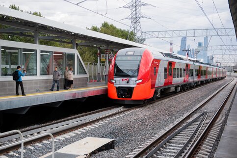
Launch of the first electric trains
The first launch of an electric train in order to check the readiness of the railway was carried out in May 2016 on one of the sections of the Moscow Ring Railway, and in July 2016, after completion of construction, along the entire length of the railway. The main electric train running along the route was the ES2G Lastochka. Conventional Russian-made electric trains were also used. With their use, some problems arose related to the discrepancy between the width of cars and electric locomotives of classical models with the distance between the tracks and the platform on the Moscow Circle. As a result, the platform at Streshneva station even had to be shifted a little to the side.

The first passenger electric train passed along the line on September 10, 2016, after which passenger trains began to operate regularly. The movement of freight trains was reduced, especially during the daytime, when electric trains are actively running. The line is also used for the movement of individual long-distance trains that bypass Moscow. The movement of steam-powered excursion trains was stopped.
Infrastructure and layout of the Moscow Ring Railway
The railway ring of the Moscow Circle includes 2 main railway lines classified as electrified. There is another third railway track running along the north of the ring, which is used for freight transport. The total length of the railway ring is 54 km. Some sections of other tracks are still not electrified.
The Moscow Ring Railway scheme is designed in such a way that it has connecting branches that allow trains to be moved between the ring railway and the radial branches of the federal railway routes. They consist of either one or two tracks (see the MKR transfer diagram). Not all of them are equipped with feeding power lines. There are branches from the freight tracks of the railway ring to industrial production facilities. There is also one branch for communication with the tram depot.
In total, the MKR scheme has 31 operating platforms for domestic passenger transportation and 12 stations for freight purposes. There is 1 tunnel 900 m long.
Stations and platforms on the Moscow Ring Road map
The stations were founded in 1908 and were originally used to handle freight traffic. Between them there were separate stops.
In the inner part of the railway ring there are now unused classic stations with station-type buildings built at the beginning of the 20th century. Previously, the railway track running along them was used for passenger transport. Modern stations can be seen on the map of the Moscow Ring Railway with stations under construction.
On the outside of the Moscow Ring Railway, entrances for parking freight trains and buildings intended for railway work were built. All this is used to form freight trains.
In 2017, the total number of stations in use (see the diagram of MKR stations) was 12 units. Of these, 4 are located on sections of branches from the Moscow Ring Road. These include: Novoproletarskaya, Northern Post.

There are 31 stopping points for city electric trains on the railway ring. These stations are passenger platforms that were built between 2012 and 2016 during the modern reconstruction of the Moscow Ring Railway. Unlike stops belonging to the radial main lines of the railway, these have the status of intracity and are equipped accordingly. They operate as public transport stops with single tickets for them.

Bridges on the Moscow Ring Road
There are a total of 6 operating bridges, 4 of which cross the Moscow Circle. The Moscow Ring Railway also crosses 32 highways and railways.
Traffic along the Moscow Ring Road
At the moment, traffic on the Moscow Ring Railway is carried out by electric trains ES2G “Lastochka”. It consists of 5 modern passenger cars, and in the coupled version - of 10 cars. In the future, the use of other locomotives (domestic production) is not excluded.

Diesel locomotives are still mainly used for freight transportation. However, the main railway lines are now electrified and allow the use of electric locomotives for transit movement. Thanks to this, it is possible to move passenger and freight trains from one transit radial railway line to another.
The MCC is the Moscow Central Circle, a new stage in the development of the capital’s transport infrastructure. Convenient and fast transport for moving, especially to those microdistricts where there are no metro lines. You can deal with complex transport interchanges on a special website that has all the necessary information.
Metro and MCC map
It's a little lower on the page. Before this, you can read the text part where you can find out about the fare, stations and operating hours. The diagram itself is very detailed and convenient to work with. To zoom in, click on the map.
MCC and metro map
Here you can see the metro map with all the interchange nodes, as well as the MCC map with stops and transfers. Below is a readable legend of all symbols, thanks to which working with the circuit becomes even easier.
Symbols on the diagram
The map shows:
- branches and stations of the Moscow metro;
- MCC stops;
- railway and bus stations, airports;
- intercept parking.
Scheme of the MCC with interchange hubs for suburban transport
This is the following diagram of the MCC, which shows the places of transfers and the route of suburban electric trains. The map indicates current and planned transfer points between the MCC and suburban trains.
Transfer scheme for the MCC and suburban electric trains
The signage and interchange stations are divided into three commissioning phases:
- Stage 1 – September 2016;
- Stage 2 – end of 2016
- Stage 3 – 2018.
Information on transfer operations is reflected in great detail, from the distance and approximate time for a transfer to additional information on the type of station.
Information about transfer stations
Plans for the development of this transport and the location of new transfer stations are also indicated.
Diagram of interchange hubs between the MCC and NGT
This diagram shows connections with ground urban transport. Everything is very informative and detailed here you can see for each transfer station:
- type of ground transport;
- transport route;
- movement interval.
Fragment of a map diagram of interchange hubs of the MCC and ground urban transport
The average time to a particular station or route is written near each station. The main transport facilities (stations, airports) are indicated. Working with the map is simple, but lacks more interactivity.
This information will be very useful for both city guests and residents of the capital. Convenient maps are worth saving to your mobile phone and using to navigate around the city. This will significantly reduce travel time and find calmer and more convenient travel options. This is especially important during rush hour and Friday crowds.
The page presents:
metro map - 2018;
metro fare - 2018;
MCC scheme;
map of the large metro ring;
large metro ring (station opening schedule);
metro map with stations under construction;
schedule for opening new metro stations until 2020.
Metro map 2016-2020
Metro map 2018 with travel time calculation: mosmetro.ru/metro-map/
%202016%20%D0%B3.jpg)
Moscow metro fare. 2018
All Moscow Metro stations are open for entry and transfer from one line to another daily from 5:30 am to 1 am.
The “Single” ticket allows you to travel by metro, monorail, bus, trolleybus or tram. One trip on a ticket is equal to one pass on any type of transport. The ticket is valid throughout Moscow, including Zone B.
LIMITED TRIP TICKETS
A “Single” ticket with a limit for 1 and 2 trips is valid for 5 days from the date of sale (including the day of sale).
Tickets for 20, 40, 60 trips are valid for 90 days from the date of sale (including the day of sale). It is recommended to book tickets for 20-60 trips on your Troika card!
From July 17, 2017, tickets for 60 trips are sold only on the Troika card!!!
| TRIP | Cost, rub. |
| 1 | 55 |
| 2 | 110 |
| 20 | 747 |
| 40 | 1494 |
| 60 | 1765 |
TICKETS WITHOUT TRIP LIMIT
A “Single” ticket without a travel limit for 1, 3 and 7 days is valid from the moment of the first pass; you must start using it no later than 10 days from the date of sale (including the day of sale). Tickets for 30, 90 and 365 days are sold only on the Troika transport card and are valid from the moment of registration on the card.
| DAY | Cost, rub. |
| 1 | 218 |
| 3 | 415 |
| 7 | 830 |
| 30 | 2075 |
| 90 | 5190 |
| 365 | 18900 |
COST OF TRAVEL WITH TROKA CARD
Tariff "Wallet"
A trip by metro and monorail - 36 rubles.
A trip by ground transport - 36 rubles.
A trip by metro and ground transport at the rate of “90 minutes” with transfers - 56 rubles. From January 2, 2018, “90 minute” tickets for 1, 2 and 60 trips are no longer sold; tickets are only available on Troika.
You can get "Troika" at the metro ticket offices, at the automated kiosks of the State Unitary Enterprise "Mosgortrans" and at the ticket offices of OJSC "Central PPK" and OJSC "MTPPK". The security deposit for Troika is 50 rubles. The deposit can be returned when returning the card to the cashier.
The card has no expiration date, the money on the card does not expire for 5 years after the last top-up.
The card can be topped up as easily as a mobile phone, but without commission and for any amount up to 3,000 rubles.
You can replenish the balance of the “Wallet” travel ticket on the “Troika” card at ticket offices and ticket machines of the metro, automated kiosks of the State Unitary Enterprise “Mosgortrans”. “United” and “90 minutes” tickets can be “recorded” on the “Troika” card at the metro ticket offices and automated kiosks of the State Unitary Enterprise “Mosgortrans”; "TAT" and "A" tickets at automated kiosks of the State Unitary Enterprise "Mosgortrans"
Topping up the balance of a Wallet ticket to a Troika card is available through Aeroexpress ticket offices and at partner terminals:
CREDIT BANK OF MOSCOW
Eleksnet
Aeroexpress
EuroPlat
Megaphone
Velobike
You can sign up for subscriptions for commuter trains at the ticket offices of commuter stations and railway stations in Moscow and the Moscow region and at ticket machines located at railway stations and marked with information posters.
MCC - Moscow Central Ring.
Opening September 10, 2016!
 |
 |
The Small Ring of the Moscow Railway (MKZD) is more than a hundred years old. Previously, passenger trains ran along it, but over time, the bulk of traffic was transported by goods. The ring served industrial zones, many of which fell into disrepair over time and, at best, were used as warehouses.Now these territories are being reorganized: housing, sports complexes, and social facilities are being built here. Developing industrial zones need good transport connections. On the rails, where previously only freight trains ran, in 10 years up to 300 million people a year will be able to travel. However, the city does not refuse cargo transportation along the Moscow Ring Railway: freight trains will run along the tracks at night. For freight traffic, additional tracks with a length of about 30 kilometers are being laid.
OPENING OF THE MOSCOW CENTRAL RING (MCC)
COST OF TRAVEL TO MCC
During the first month of operation of the MCC, travel on the Moscow Central Circle will be free. After the end of the starting month of operation, one trip on the MCC will cost 50 rubles, two - 100 rubles, no more than 40 trips - 1,300 rubles, no more than 60 - 1,570 rubles. A travel ticket without a travel limit will cost passengers 210 rubles for a day, 400 rubles for three days, and 800 rubles for seven days.
ABOUT It will be possible to pay for trips using city tickets, such as “Troika” and “United”. Passengers will not have to pay twice: transfers from the Moscow Ring Railway to the metro will be free for one and a half hours. This time should be enough to go down into the subway, and not necessarily to the nearest station.Beneficiaries will retain the right to free travel around the ring. They will be able to use a Muscovite social card. Students and other students will be able to travel on the Moscow Ring Railway using discounted metro cards.
TRAVEL TIME
During peak hours, trains will run every six minutes, at other times - at intervals of 11-15 minutes. It will be possible to drive a full circle along the Moscow Ring Road in an hour and a quarter. The new transport circuit will make travel around the capital 20 minutes shorter on average.According to preliminary calculations, travel time between stations will be from 1.6 to 4.2 minutes.The transfer will take a matter of minutes, and 11 stations are organized on the “dry feet” principle. This means that you won’t have to go outside from the stations. A system of covered passages and galleries will protect pedestrians from rain, snow, and cold. And four stations will have glass walls and roofs to allow natural light in the lobbies.
INTERCEPTION PARKING
Motorists will be able to leave their car in intercept parking lots at 13 transport hubs and transfer to public transport. For citizens with limited mobility, elevators, escalators, lifts will be installed, and tactile tiles will be laid.
Big metro ring. Opening schedule

![]() "Business Center" (opened February 26, 2018)
"Business Center" (opened February 26, 2018)
"Petrovsky Park" (opened February 26, 2018)
"CSKA" ("Khodynskoye Pole") (opened February 26, 2018)
"Shelepikha" (opened February 26, 2016)
"Khoroshevskaya" (opened February 26, 2018)
![]() "Aviamotornaya" (2019)
"Aviamotornaya" (2019)

The main thing that needs to be done at the second stage of the development of the subway is to build a new ring line - the Third Interchange Circuit. Its length will be 42 km. Total n planned to open bmore than 160 km of new stations.
By 2020, the congestion of the capital's metro should decrease by almost half (By 2020, the capital's metro will increase by 78 stations):
"“We believe that it is this additional circuit that will allow us to relieve the existing lines,” sums up M. Khusnullin. — Passengers will not have to travel to the city center to switch to another line.
Among other things, it is through the new ring that the subway is planned to be connected to the Moscow Ring Railway. The main interchange hubs will be the Khoroshevskaya and Nizhegorodskaya Street stations. At the same time, underground and surface trains will run according to an agreed schedule.
“By building the Third Interchange Circuit, we have the opportunity to “string” additional stations onto it, which will be needed when developing new territories,” explains M. Khusnullin. — As soon as we begin to develop the new territory, all the infrastructure will already be prepared.
Ultimately, due to the creation of new underground routes, the congestion of the capital’s metro should be reduced by almost half. If now, during peak hours, up to 8 people per 1 sq. m are packed into the cars. m, then to 2020 The metro will reach the standard load - about 4.5 people per square meter.".
After the construction of the second ring line:
- Instead of the current 40 minutes it takes to get from the Yugo-Zapadnaya station to Kuntsevskaya, using the second ring you will get there in just 10 minutes!
- now the journey from Kaluzhskaya to Sevastopolskaya takes 35 minutes, but it will only take 3 minutes;
- the trip from Sokolniki to Elektrozavodskaya will take only 3 minutes instead of 22 minutes;
- the route from Kashirskaya to Tekstilshchiki takes 30 minutes, but it will take 2 minutes;
- The travel time from Rizhskaya to Aviamotornaya is currently 20 minutes, and with the opening of the TPK it will be reduced exactly by half!
Schedule (dates) of openings
Moscow metro stations 2014-2020
Since 2012, the capital has been implementing a metro development program in accordance with Moscow government decree No. 194-PP dated May 4, 2012. As part of the program, the Novokosino, Pyatnitskoye Shosse and Alma-Atinskaya stations were already opened in 2012, and by 2020, more than 155 km of new lines and 75 stations will be built.

year 2014:
![]() "Lesoparkovaya" (opened February 28, 2014)
"Lesoparkovaya" (opened February 28, 2014)
![]() «
Bitsevsky Park "(opened February 27, 2014)
«
Bitsevsky Park "(opened February 27, 2014)
![]() "Spartak" (opened August 27, 2014)
"Spartak" (opened August 27, 2014)
Sokolnicheskaya line:
![]() "Troparevo" (opened)
"Troparevo" (opened)
2015:
"Kotelniki" (opened September 21, 2015)
![]() « Butyrskaya
« Butyrskaya
![]() «
Fonvizinskaya" (opened in September 2016)
«
Fonvizinskaya" (opened in September 2016)
![]() «
Petrovsko-Razumovskaya"(opened September 2016)
«
Petrovsko-Razumovskaya"(opened September 2016)
Sokolnicheskaya line:
"Rumyantsevo" (opened January 18, 2016)
2017:
Zamoskvoretskaya line:
![]() «
Khovrino" (opened December 31, 2017)
«
Khovrino" (opened December 31, 2017)
Kalininsko-Solntsevskaya line
![]() «
Lomonosovsky Prospekt"(opened March 16, 2017)
«
Lomonosovsky Prospekt"(opened March 16, 2017)
"Minskaya"(opened March 16, 2017)
![]() «
Ramenki » (opened March 16, 2017)
«
Ramenki » (opened March 16, 2017)
2018:
Lyublinsko-Dmitrovskaya line:
![]() «
Verkhniye Likhobory"(opened March 22, 2018)
«
Verkhniye Likhobory"(opened March 22, 2018)
![]() «
District » (opened March 22, 2018)
«
District » (opened March 22, 2018)
![]() «
Seligerskaya "(opened March 22, 2018)
«
Seligerskaya "(opened March 22, 2018)
Kalininsko-Solntsevskaya line
"Ozernaya" (Ochakovo)(opened August 30, 2018)
![]() "Prokshino" (2020)
"Prokshino" (2020)
![]() "Stolbovo" (2020)
"Stolbovo" (2020)
![]() "Filatov Meadow" (2020)
"Filatov Meadow" (2020)
Kozhukhovskaya line:
![]() "Kosino" (2020)
"Kosino" (2020)
"Lukhmanovskaya" (2019)
"Nekrasovka" (2019)
« Nizhegorodskaya street"(2020)
"Okskaya Street" (2020)
Moscow Central Circle (MKR) station diagram, interactive MCC station diagram on the map, detailed information, train schedule.
Interactive map of the Moscow Circle Railway (MCC map) and metro transfer stations, MCC train schedule
MCC fare
Tariffs for travel on the Moscow Central Circle (MCC).
- Ticket for one and two trips to the MCC – 57 and 114 rubles, respectively.
- Directions for card users “Troika” on the MCC – 40 rubles.
- "Unified" for 1 month; metro, trolleybus, bus, tram (no more than 70 trips on the metro/MCC) – 2900 rubles.
The “Single” ticket allows you to travel by metro, monorail, bus, trolleybus or tram. One trip on a ticket is equal to one pass on any type of transport. The ticket is valid throughout Moscow, including Zone B.
The validity period of a “Single” ticket for 1–2 trips is 5 days, including the day of sale.
Tariffs: off. website – mosmetro.ru/tariffs/unity/
- Transfers from the metro to the Moscow Central Circle and back are carried out without charging an additional fee.
The exception is transfers between stations Dubrovka MCC and Kozhukhovskaya metro station, as well as between stations Verkhnie Kotly MCC and Nagatinskaya metro station.
MCC operating schedule and train intervals
Trains operate on the MCC daily from 05:45 to 01:00 Moscow time.
- Weekdays: during rush hour 5 minutes. – (from 7:30 to 11:30 Moscow time and with 16:00 to 21:00 Moscow time)
- Weekends: during rush hour 6 min. – (from 13:00 to 18:00 Moscow time) and 10 minutes during off-peak times.
In accordance with the new schedule of the MCC, Lastochka makes 354 flights on weekdays, and 300 on weekends. For the convenience of passengers, at 12 stop points with the highest passenger traffic, the stop time of the train has been increased from 30 seconds to 1 minute.
These are the platforms “Andronovka”, “Lokomotiv”, “Rostokino”, “Botanical Garden”, “Vladykino”, “Okruzhnaya”, “Panfilovskaya”, “Business Center”, “Kutuzovskaya”, “Gagarin Square”, “Zil”, “ Avtozavodskaya". Thus, travel time on the MCC will increase from 84 to 90 minutes.
MCC train schedule
Detailed description of stations of the Moscow Central Circle.
KHOROSHEVO - SORGE - PANFILOVSKAYA - STRESHNEVO - BALTIC - KOPTEVO - LIKHOBORY - DISTRICT - VLADYKINO -BOTANICAL GARDEN-ROSTOKINO -BELOKAMNAYA -BOULEVARD-ROKOSSOVSKOGO-LOCOMOTIVE -IZMAILOVO -SOKOLINAYA MOUNTAIN -THE ENTHUSIAST HIGHWAY-ANDRONOVKA -NIZHNOGORODSKAYA -NOVOKHOKHOLOVSKAYA -UGRESHSKAYA -DUBROVKA -AVTOZAVODSKAYA -ZIL -UPPER BOILERS -CRIMEASKAYA -GAGARIN SQUARE-LUZHNIKI -KUTUZOVSKAYA -BUSINESS CENTER -SHELEPIKHA
Train schedule at TPU Khoroshevo station
– located in the Northern and Northwestern administrative districts of Moscow, within the boundaries of the Khoroshevo-Mnevniki and Khoroshevsky districts.
The main planning and transport connections of the territory are the MCC, Marshal Zhukov Avenue, 3rd Khoroshevskaya Street and Khoroshevskoye Highway.
The Khoroshevo transport hub is planned to provide a transfer to ground urban passenger public transport. It is planned to construct new stopping points with drive-in pockets for public transport on 3rd Khoroshevskaya Street and Marshal Zhukov Avenue.
To the east of this site Polezhaevskaya metro station is within walking distance Tagansko-Krasnopresnenskaya line.
The transport hub includes the construction of northern and southern passenger terminals, an overground pedestrian crossing with service facilities and a stopping point, consisting of a coastal and island platform, while the platforms are partially located directly on the overpass over the Khoroshevskoe highway and structurally form a single whole with it
Transport:
Train schedule TPU Sorge
TPU "Sorge"– located in the Northern and Northwestern administrative districts of Moscow, within the boundaries of the Khoroshevo-Mnevniki, Shchukino, Sokol and Khoroshevsky districts.

The main planning and transport connections of the territory are the MCC, Sorge, Berzarina, Marshala Biryuzova, 3rd Khoroshevskaya and Kuusinen streets. There is a station not far from the planned territory "October Field" Moscow metro.
The Sorge transport hub will provide a transfer to ground urban passenger transport. For this purpose, it is planned to construct a settling-turning area, construct new stopping points, with drive-in pockets for public transport on Sorge and Marshal Biryuzov streets.
Transport:
- Buses No. 48, 64, 39, 39k
- Trolleybuses No. 43, 86, 65
Train schedule TPU Panfilovskaya
TPU "Panfilovskaya" located in the Northern and Northwestern administrative districts of Moscow, within the boundaries of the Sokol and Shchukino districts.

It is planned to organize a convenient transfer from the Moscow Ring Railway to buses and trolleybuses stopping on nearby streets - Panfilov, Alabyan and Narodnogo Opolcheniya. It is planned to install new stopping points with drive-in pockets for public transport along Panfilov Street. Three elevated pedestrian crossings, passenger platforms on the MCC, exits to the platforms, premises for ticket offices and turnstiles are also being built.
The Panfilovskaya transport hub is located within walking distance from the Oktyabrskoye Pole station. Tagansko-Krasnopresnenskaya line of the Moscow metro.
Transport:
- Buses No. 100, 105, 26, 691, 88, 800
- Trolleybuses No. 19, 59, 61
Train schedule TPU Streshnevo
– located in the Northern and Northwestern administrative districts of Moscow, within the boundaries of the Sokol, Voikovsky, Shchukino and Pokrovskoye-Streshnevo districts.

The main planning and transport connections are the Moscow Circle Railway, the Riga direction of the Moscow Railway, 1st Voikovsky, Svetly and 1st Krasnogorsky passages, Konstantin Tsarev Street and Volokolamskoye Highway.
In 2017 a transfer to the Riga direction will be organized from the Streshnevo transport hub Moscow Railway, for which a new stopping point Streshnevo will be built. By the time passenger rail traffic on the MCC is launched, a transfer will be organized from the Volokolamskaya stopping point to ground urban passenger transport, settling and turning areas will be arranged, and new stopping points will be organized with the construction of drive-in pockets along the 1st Krasnogorsky Passage and Volokolamsk Highway.
Transport:
- Buses No. 88
- Trolleybuses No. 12, 70, 82
- Trams No. 23, 30, 31, 15, 28, 6
- Suburban railway transport Pl. Streshnevo (Riga direction of the Moscow Railway, promising, 2017)
Train schedule TPU Baltiyskaya
– located in the Northern Administrative District of Moscow within the boundaries of the Voikovsky district. The main planning and transport connections are Leningradskoye Highway, Admiral Makarov, Klara Zetkin streets, Novopetrovsky Proezd, 4th Novopodmoskovny Lane and Zoya and Alexander Kosmodemyansky Street.

The Baltiyskaya transport hub is located near the Voikovskaya station of the Zamoskvoretskaya line Moscow metro, and provides transfer to the metro. There will also be a transfer to city passenger transport (bus, trolleybuses and minibuses). It is planned to build settling and turning areas and install new stopping points for ground urban passenger transport along Admiral Makarov Street and Novopetrovsky Proezd. In the future, an overground pedestrian crossing will be built from Admiral Makarov Street to Novopetrovsky Proezd over the railway tracks.
From the pedestrian crossing there will be exits on both sides of the Baltiyskaya stopping point. The elevated pedestrian crossing will be connected to the Metropolis shopping center, from where it will be possible to access the metro. At the same time, a transition from the MCC to the metro and along the road network will be organized.
Transport:
Car parking:
Number of parking spaces: 1000, year of construction: 2025
Train schedule TPU Koptevo
– located in the Northern Administrative District of Moscow within the boundaries of the Golovinsky and Koptevo districts. The main planning and transport connections are Koptevskaya, Mikhalkovskaya, Onezhskaya streets and Cherepanov passage. At the intersection of the listed planning connections in the Mikhalkovskaya interchange area there is a tram ring of routes running from the Voikovskaya and Timiryazevskaya stations.

The transport hub project provides for the construction of a turnstile and ticket office pavilion, an elevated pedestrian crossing, providing access to the tram ring and public transport boarding areas on the street. Mikhalkovskaya.
Transport:
- Buses No. 123, 621, 90, 22, 72, 801, 87
- Trams No. 23, 30
Train schedule TPU Likhobory
– located in the Northern Administrative District of Moscow within the boundaries of the Koptevo, Golovinsky, Western Degunino and Timiryazevsky districts.

The main planning and transport connections are the MCC, Oktyabrskaya Railway, Cherepanov Passage, Oktyabrskaya Railway Line Street and Likhoborskaya Embankment.
By the time passenger rail traffic on the MCC is launched, a transfer will be organized from the MCC station "Likhobory" to the NATI platform, as well as to ground urban passenger transport: the construction of a settling and turning area, the construction of new stopping points along Cherepanov Passage.
Transport:
- Buses No. 114, 123, 179, 204, 87
- Trolleybuses No. 57
- Suburban railway transport Pl. NATI (Leningrad direction of Railways)
- Car parking: Number of parking spaces: 200, Year of construction: 2017
Train schedule TPU Okruzhnaya
– located in the North-Eastern and Northern administrative districts of Moscow, within the boundaries of the Marfino, Otradnoe, Timiryazevsky and Beskudnikovsky districts. The main planning and transport connections are the MCC, the Savelovskoe direction of the Moscow Railway, Lokomotivny and 3rd Nizhnelikhoborsky passages and Station Street.

TPU "Okruzhnaya" will provide transfer to the eponymous stopping point of the Savelovsky direction of the Moscow Railway and on promising station "Okruzhnaya" Lyublinsko-Dmitrovskaya line of the Moscow metro (opening in 2017). It will also be possible to transfer to ground urban passenger transport.
Transport:
Train schedule TPU Vladykino
– located in the North-Eastern administrative region, districts: “Otradnoe” and “Marfino”. The Vladykino transport hub will provide a transfer to the Vladykino station Serpukhovsko-Timiryazevskaya line of the Moscow metro, as well as on ground urban passenger transport. An elevated pedestrian crossing will lead from the MCC platforms, which will go to the southern and northern lobbies of the Vladykino metro station.

The TPU project provides for the construction of an MCC station with the installation of ticket offices and turnstiles, an elevated pedestrian crossing over the railway, which will connect the southern and northern metro lobbies. It is also planned to build a settling and turning area for ground urban passenger transport.
Transport:
Train schedule TPU Botanical Garden
TPU "Botanical Garden"– located in the North-Eastern administrative district of Moscow in the Sviblovo, Ostankino and Rostokino districts. The main planning and transport connections are the passage and Serebryakova street, st. Wilhelm Pieck, 1st Leonov Street.
The Botanical Garden transport hub is located in close proximity to the Botanical Garden station. Moscow metro and will be connected to it by an underground pedestrian crossing. An underground pedestrian crossing will run under the railway and connect Serebryakov Passage and 1st Leonov Street.
Transport:
Train schedule TPU Rostokino
TPU "Rostokino"– located in the North-Eastern administrative district of Moscow. The territory borders the Yaroslavsky, Rostokino and Sviblovo districts.
The main planning and transport connections are Mira Avenue, Yaroslavskoe Highway, Severyaninsky Overpass.
The Rostokino transport hub will provide a transfer to the Severyanin stop point Yaroslavl direction of the Moscow Railway, as well as for ground urban passenger transport: reconstruction of existing and construction of new stopping points, construction of a settling and turning area along Mira Avenue towards Letchika Babushkina Street.
Transport:
- Buses No. 136, 172, 244, 316, 317, 388, 392, 425, 451, 499, 551, 576, 789, 834, 93
- Trolleybuses No. 14, 76
- Trams No. 17
- Suburban railway transport Pl. Severyanin (Yaroslavl direction of the Moscow Railway)
Train schedule TPU Belokamennaya
TPU "Belokamennaya"– located: Eastern administrative district of Moscow, within the boundaries of the Losiny Ostrov National Park. The entire territory is located within the boundaries of the Bogorodskoye and Metrogorodok districts.
The main planning and transport connections are the MCC, Yauzskaya Alley, Losinoostrovskaya Street and Abramtsevskaya Clearing.
The nearest metro station is the Rokossovsky Boulevard station Sokolnicheskaya metro line, which is located at the intersection of Ivanteevskaya Street and Otkrytoye Shosse. Transport services for the population and working areas of Bogorodskoye and Metrogorodok of the Eastern Administrative District are currently provided by ground public transport with delivery to the Rokossovsky Boulevard station.
The Belokamennaya transport hub will provide a transfer to ground urban passenger transport. For this purpose, it is planned to construct a turning area for public transport on Yauzskaya Alley street.
Transport:
Train schedule TPU Rokossovsky Boulevard
– located in the Eastern Administrative District of Moscow within the boundaries of the Bogorodskoye and Metrogorodok districts. The main planning and transport connections are the MCC, Otkrytoye Shosse and Ivanteevskaya Street.
The transport hub "Rokossovskogo Boulevard" is located near the existing "Rokossovskogo Boulevard" station Sokolnicheskaya line of the Moscow metro, and provides for a transfer to the latter. A transfer to ground urban passenger transport will also be provided.

For this purpose, it is planned to build a settling-turning area and construct boarding fronts for urban passenger transport along Otkrytoye Highway, 6th Podbelsky Passage and Ivanteevskaya Street.
Transport:
Train schedule TPU Lokomotiv
– located in the Eastern Administrative District of Moscow, within the boundaries of the Preobrazhenskoye, Golyanovo and Izmailovo districts.
The Lokomotiv transport hub is located near the existing Cherkizovskaya station Sokolnicheskaya line of the Moscow metro, and provides for transplantation to the last one. There will also be a transfer to city passenger transport (bus, trolleybus and minibus). Pedestrian connections are provided with the southern vestibule of the Cherkizovo metro station.

The transplant is carried out according to the “dry legs” principle. The construction of a turning circle for ground transport and the construction of new boarding fronts for ground urban passenger transport along Okruzhny Proezd near the pavilions of the Cherkizovskaya metro station are underway.
Transport:
Train schedule TPU Izmailovo
– located in the Eastern Administrative District within the boundaries of the Izmailovo, Sokolinaya Gora and Preobrazhenskoye districts.

The transport hub will unite Izmailovskoe highway, Okruzhnoy proezd(one of the sections of the North-East Expressway), station "Partizanskaya" Arbatsko-Pokrovskaya line of the Moscow metro and Projected passage No. 890.
The Izmailovo platform on the MCC and the Partizanskaya metro station will be connected by an elevated pedestrian crossing, which will stretch from Okruzhny Passage over the roadway of the North-Eastern Expressway and connect the Izmailovo MCC station and the Partizanskaya metro station of the Arbatsko-Pokrovskaya line. The two passage lobbies will contain ticket offices, sanitary rooms and elevators. An MCC terminal with turnstiles and escalators for passengers to exit to the platforms will be built at the transport hub.
Transport:
Train schedule TPU Sokolinaya Gora
– located in the Eastern Administrative District of Moscow. The planned territory is located within the boundaries of several districts: Sokolinaya Gora and Izmailovo. The metro stations closest to the transport hub are Partizanskaya and Shosse Entuziastov.

On the eastern side of the transport hub there is a specially protected area of the Izmailovo natural and historical park. On three sides, the territory is framed by existing streets and passages (Okruzhny Passage, 8th Sokolinaya Gora Street, Electrodny Passage and the overpass between them, located along the southern border).
Transport:
- Buses: No. 86
- Car parking: Number of parking spaces: 365 Year of construction: 2016
Train schedule TPU Shosse Entuziastov
– located in the Eastern Administrative District of Moscow, in the Sokolinaya Gora district, a small area is located within the boundaries of the Perovo district.

The main planning and transport connections are the MCC, the North-Eastern Expressway under construction, Entuziastov Highway, st. Utkina. In the southern part of the projected area, on both sides of Entuziastov Highway, there are exits from the Entuziastov Highway metro station. Passengers will exit the MCC platform into an underground pedestrian crossing that connects Utkina Street and Entuziastov Highway.
Transport:
Train schedule TPU Andronovka
– located in the South-Eastern Administrative District in the Lefortovo and Nizhegorodsky districts and the Eastern Administrative District in the Perovo district.

The main planning and transport connections are Freser highway, Andronovskoe highway, st. 2nd Frezernaya, 1st Frezernaya st., ave. Fraser, st. 5th Cable, st. Pond-Klyuchiki.
The Andronovka transport hub will provide a transfer to the Freser railway platform Ryazan direction railway and ground urban passenger transport with transportation to the Aviamotornaya station of the Kalininskaya metro line.
Transport:
- Suburban railway transport Pl. Frezer (Kazan direction of Moscow Railways)
- Car parking: number of parking spaces: 60 Year of construction: 2016
Train schedule TPU Nizhegorodskaya
– located in the South-Eastern district of Moscow. Its main part is located within the boundaries of the Lefortovo and Nizhny Novgorod districts. The main planning and transport connections are Ryazansky Prospekt, Frazer Highway and Kabelnaya Street.

TPU "Nizhegorodskaya" will provide a transfer to the stop point "Karacharovo" Gorky direction of the railway, as well as to ground urban passenger transport. In 2018 This transport hub will include the Nizhegorodskaya Street station Kozhukhovskaya line of the Moscow metro.
Transport:
Train schedule TPU Novokhokhlovskaya
– located in the South-Eastern Administrative District in the Tekstilshchiki and Nizhegorodsky districts.

Currently, the main planning and transport connections are: Third Transport Ring, st. Novokhokhlovskaya, st. Nizhnyaya Khokhlovka.
The Novokhokhlovskaya transport hub, after the launch of traffic along the MCC, will provide a transfer to ground urban passenger transport. In 2017 from this transport hub there will be a transfer to the Kursk direction of the Moscow Railway, for which a new platform will be built.
Transport:
- Buses No. 106, new routes
- Suburban railway transport Pl. Novokhokhlovskaya (Kursk direction of the Moscow Railway, promising, 2017)
Train schedule TPU Ugreshskaya
– located in the South-Eastern administrative district of Moscow. Its main part is located within the boundaries of several districts: Yuzhno-Portovy and Pechatniki. The main connection with the city, providing transport services to the territory under consideration, is Yuzhnoportovaya Street with access to the Third Ring Road.

Along Yuzhnoportovaya Street organized bus routes transporting passengers (district, interdistrict) and transportation of the population to the Kozhukhovskaya metro station and in the opposite direction along Sharikopodshipnikovskaya Street to the Dubrovka metro station. Within the project boundary is the final turning circle of the tram line running along Ugreshskaya Street and then through the third transport ring along Sharikopodshipnikovskaya Street to the Dubrovka metro station.
At the Ugreshskaya transport hub, 2 passenger terminals of 1.5 thousand square meters each and an overhead pedestrian crossing with an area of 10.9 thousand square meters will be built. m. It is also planned to build a technological link from the northern passenger terminal of the Ugreshskaya transport hub to Volgogradsky Prospekt.
Transport:
- Buses No. 154, 33, 603, 71, 195, 134, 185, 61, 628, 789
- Trolleybus No. 38
- Tram No. 20,40,43
Train schedule TPU Dubrovka
– located in the South-Eastern administrative district of Moscow and is located within the boundaries of the Yuzhno-Portovy and Pechatniki districts.

The Dubrovka transport hub will provide a transfer to the Dubrovka station Lyublinsko-Dmitrovskaya line of the Moscow metro, as well as on ground urban passenger transport. The final turning circle of the tram line running along Ugreshskaya Street is located within the project boundary.
Transport:
Train schedule TPU Avtozavodskaya
– located in the Southern Administrative District of Moscow, in the Danilovsky district. The main planning and transport connections are Avtozavodskaya Street, Third Transport Ring, 1st and 2nd Avtozavodskaya passages, 1st and 2nd Kozhukhovsky, st. Lobanova, st. Trofimova.

Transport hub "Avtozavodskaya" will provide a transfer to the station "Avtozavodskaya" Zamoskvoretskaya line of the Moscow metro, as well as on ground urban passenger transport.
Transport:
Train schedule TPU ZIL
– located in the northern part of the Southern Administrative District of Moscow in the Danilovsky district.
On the territory of the ZIL transport hub there will be two terminals with ticket offices and turnstiles - southern and northern, on the outer and inner sides of the MCC. In addition, it is planned to construct an administrative and business building with retail facilities, parking facilities, and above-ground and underground parking. For public transport, a settling and turning area will be organized on the western side of the MCC and a road network will be developed.

The transport hub project provides for the construction of a northern technological connection with the installation of ticket offices and turnstiles, providing access from the north-eastern terminal towards the territory of the Ice Palace (inner side from the MCC) and to the boarding fronts for ground urban passenger transport (outside the MCC); southern technological connection with the installation of ticket offices and turnstiles, providing access from the southwestern terminal to the public and business zone complex (inner side from the MCC) and to the industrial territory of AMO "ZIL" (outside from the MCC); flat dual-use parking with a total capacity of 120 cars for the needs of the ZIL transport hub and visitors to retail and office facilities; placement of settling and turning areas for urban passenger transport on both sides of the railway
Transport:
- Buses: new routes (clarification)
Train schedule TPU Verkhniye Kotly
– located in the Southern Administrative District in the Donskoy, Nagatino-Sadovniki and Nagorny districts.

On the Moscow Central Circle located between the Tulskaya and Nagatinskaya stations Serpukhovsko-Timiryazevskaya metro line and the stopping point “Nizhnie Kotly” of the Paveletsky direction of the railway.
The Verkhnie Kotly transport hub, after the launch of traffic along the MCC, will provide a transfer to ground urban passenger transport. In 2017 From this transport hub there will be a transfer to the Paveletskaya direction of the Moscow Railway, for which a new platform will be built.
From the north, the territory of the transport hub is adjacent to a residential microdistrict and enterprises of the Varshavskoye Shosse industrial zone. From the south - the coastal zone of the Kotlovka River and the enterprises of the Varshavskoye Shosse industrial zone.
Transport:
- Buses No. 25, 44, 142, 147, 275, 700
- Trolleybus No. 1, 1k, 40, 71, 8
- Tram No. 16, 3, 35, 47
- Suburban railway transport Paveletskaya direction of the Moscow Railway (promising, 2017)
Train schedule TPU Krymskaya
TPU "Krymskaya"– located in two administrative districts, Southern and Southwestern, in the Donskoy, Nagorny and Kotlovka districts.
The main transport connections are: Sevastopolsky Avenue, Zagorodnoye Shosse, 4th and 5th Zagorodnye Proyezds, Bolshaya Cheremushkinskaya Street. The basis of the formed interchange hub is the designed railway station “Sevastopolskaya” (second stage of construction) and ground urban passenger transport serving this territory along Sevastopolsky Avenue. An overground pedestrian crossing with exits to the railway platform will be built between 4th Zagorodny Proezd and Sevastopolsky Prospekt. Also, as part of the preparation for the launch of traffic around the ring, a reconstruction of the surface urban transport stop along the 4th Zagorodny Proezd will be carried out with the installation of a drive-in pocket.
From the north, residential areas of the Donskoy district adjoin the territory of the transport hub. To the south are the residential areas of the Kotlovka district, and to the west of Sevastopolsky Prospekt are the enterprises of the Varshavskoye Shosse industrial zone.
Transport:
- Buses No. 121, 41, 826
- Trams No. 26, 38
Train schedule TPU Gagarin Square
TPU "Gagarin Square"– located in the Western administrative district of Moscow within the boundaries of the Academichesky district. The main planning and transport connections of this territory are the Third Transport Ring, Leninsky Prospekt, 60-Letiya Oktyabrya Avenue and Vavilova Street.
The Gagarin Square transport hub will provide a transfer to the Leninsky Prospekt station Kaluzhsko-Rizhskaya line of the Moscow metro, as well as on ground urban passenger transport. “Gagarin Square” is the only station on the MCC located underground. The transition to the Leninsky Prospekt metro station will be via an underground pedestrian crossing.
Transport:
Train schedule TPU Luzhniki
– located along the street. Khamovnichesky Val, in the Khamovniki district of the Central Administrative District. The stopping point consists of two shore-type landing platforms and a ground-based vestibule with access to the street. Khamovnichesky Val.

Transport hub "Luzhniki" will provide a transfer to the station "Sportivnaya" Sokolnicheskaya line of the Moscow metro, as well as on ground urban passenger transport. The Luzhniki transport hub will become the main transport hub of the main arena of the 2018 FIFA World Cup.
Transport:
Train schedule TPU Kutuzovskaya
– located in the Western Administrative District of Moscow within the boundaries of the Dorogomilovo district. The main highways providing transport services to the territory are the Third Transport Ring and Kutuzovsky Prospekt.

The Kutuzovskaya transport hub will provide a transfer to the Kutuzovskaya station Filyovskaya line of the Moscow metro, as well as on ground urban passenger transport.
Transport:
Train schedule TPU Business Center
– located in the southwestern part of the Central Administrative District of Moscow in the Presnensky district. Presnensky District borders on the following districts: Khoroshevsky, Khoroshevo, Mnevnikovsky, Filevsky Park, Tverskoy, Dorogomilovo, Begovoy District and Arbat.

It will be one of the largest on the MCC. He will connect the Mezhdunarodnaya metro station and the Delovoy Tsentr stop point in a warm circuit on the MCC. Walking communication will be provided to the Testovskaya platform in the Smolensk direction.
It is planned to build a parking lot, an underground passage from the Business Center transport hub to Moscow City, and an above-ground pedestrian gallery from the Business Center transport hub directly to the Moscow City building (above Testovskaya Street). The elevated pedestrian crossing will be built in the second stage.
The transport hub includes the construction of an office center and parking areas (second stage). The total construction area is 151 thousand sq. m.
A terminal with ticket offices and turnstiles is being built under the overpass of the Third Transport Ring, which will be connected to the northern pavilion of the International metro station. Thus, From the Delovoy Tsentr MCC station you can immediately go down to the metro lobby, and also go out onto Testovskaya Street to stops of ground urban transport, or through an underground pedestrian crossing to Moscow City. There will also be an exit to the opposite side of the transport hub to the Botanical Garden.
Transport:
Train schedule TPU Shelepikha
TPU "Shelepikha"– located in the Central Administrative District of Moscow within the boundaries of the Presnensky district. The main planning and transport connections are the MCC, the Smolensk direction of the Moscow Railway, Shmitovsky proezd, Shelepikhinsky dead end and Ermakova Roshcha street.
The MCC is essentially the second ring metro line with a unified tariff ticket system of the Moscow Metro. 31 stations (TPU) were built on the MCC. From any transport hub it is possible to transfer to ground urban passenger transport.
At 17 out of 31 stations it is possible to change to 11 metro lines. Also, at 10 transport hubs you can transfer to commuter trains.
The rolling stock on the MCC is represented by high-speed electric trains "Lastochka" manufactured by Siemens AG. Trains consist of 5 cars.
Operation of the electric train is possible at ambient temperatures from −40°C to +40°C. The cars are equipped with double-leaf sliding doors, two on each side of the car.
 The electronics of the cars contain built-in lighting, loudspeakers, and digital information displays. To recharge mobile devices, the carry-on luggage compartments have built-in electrical sockets designed for 220v AC voltage.
 The head carriages of the train have bathrooms with dry toilets.(one per carriage), the bathrooms are equipped with special equipment for people with limited mobility.
There are 28 Lastochka high-speed electric trains running on the MCC. The train moves almost silently and can accelerate to 120 kilometers per hour. During peak hours, trains run every six minutes, at other times - at intervals of 11–15 minutes. The total duration of the trip around the ring is about 75-85 minutes.
Technologies
"Smart" escalators with motion sensors
Energy-saving escalators have been installed on the Moscow Central Circle (MCC). Smart escalators start moving only when passengers approach them. Accordingly, if there are no passengers on the escalator, it automatically slows down and stops.
Opening doors “On demand”
Doors on trains open at the request of passengers. The doors open only when the train is completely stopped on the platform, and only when the doors are ready to open, and a special green signal lights up.
 There are special stickers on the outer and inner sides of the doors informing that before entering or exiting, you must press the corresponding button to open the doors.
 Thermal curtain / Climate control system
In cold weather, electric trains on the Moscow Central Circle will include a thermal curtain on the doors. The thermal curtain turns on automatically at stops, when the doors are opened.
“Warm air is exhausted directly in front of the doors in the car, creating a thermal curtain and preventing cold air from entering inside,” the press service of JSC Russian Railways.
The thermal curtain will protect the carriage from sudden temperature changes and will be able to maintain a comfortable temperature for passengers at any time of the year.
MCC cars have an automatic heating system that turns on when the ambient temperature drops below the air temperature in the train. An antibacterial air disinfection system is integrated into the climate control of trains, which will protect passengers from all kinds of infections and viruses in the carriages, which is undoubtedly a relevant technology. solution for public transport
The Moscow Central Circle (MCC) is an abbreviation that has been in use quite recently; the ring itself is used even less for passengers. On metro maps, the ring is indicated by line 14, although it looks a little different.
Metro or train
Circular railway, Small ring of the Moscow railway, Moscow ring railway, Moscow central ring - all these definitions in one form or another refer to the same object.
The first train at the Luzhniki station of the Moscow Central Circle. Photo: website/Andrey Perechitsky
In the new name - MCC - the mention of the railway has been removed, on metro maps it is indicated as line 14, transfers with the metro are free (even in the "metro - MCC - metro" option), a separate page for the MCC has been created on the metro website... So everything can be... Is the MCC a metro?
The MCC infrastructure itself (tracks, stations, etc.) belongs to Russian Railways. The ring is physically connected to other sections of the railways; the use of the ring for freight traffic is not canceled and is quite possible. The rolling stock, "Swallows", has been traveling on other sections of Russian railways for several years now. At MCC stations you can find workers in gray Russian Railways uniforms, information boards and part of the navigation at the MCC stations themselves - according to the brand book and Russian Railways standards. Even the turnstiles are like those at many suburban stations (albeit equipped with metro validators). So, is the MCC an electric train?

Navigation in the transition between platforms of the Khoroshevo station of the Moscow Central Circle. Photo: website/Andrey Perechitsky
If we approach the issue formally, then the MCC is a real railway, however, in the mass consciousness, the use of the railway for movement within one city is still of little use, moreover, the MCC is integrated mainly with the metro, and the ring is precisely urban transport, and not suburban, which includes the green electric trains familiar to city dwellers. This is also why navigation and tariffs are designed in such a way that the passenger feels that he is on the 14th metro line, although in fact the MCC, of course, is not a metro.

Turnstiles at Luzhniki station of the Moscow Central Circle. Photo: website/Andrey Perechitsky
In relation to the MCC, it is appropriate to use the term “urban train” - a type of transport in Russia that is not very common.
Abroad, this type of transport is widespread and quite popular. For example, in Germany, Austria, and Switzerland there is S-bahn, which occupies an intermediate position between urban public transport and classic commuter trains.
The MCC itself breaks the mold of many definitions, and similar debates have been going on on thematic forums for many months - “What is the new ring anyway?”
The MCC, metro, monorail and ground transport are all elements of the city’s unified transport system, so asking the question “is the MCC part of the metro?” not entirely true. To the question “Does the MCC belong to the Moscow transport system?”, it is certainly correct and correct to answer “Yes”, as well as to a similar question regarding the metro or monorail.
The Lastochka train arrives at the Khoroshevo station of the Moscow Central Circle. Photo: website/Andrey Perechitsky
The main flow to the MCC should still be a transfer from the metro; there will be fewer “pure” independent trips around the ring. At the same time, such stations as Sorge (formerly Novopeschanaya), Krymskaya (formerly Sevastopolsky Prospekt), Streshnevo (formerly Volokolamskaya) have created (in the case of Sorge, they will create) new transport hubs. Residents of nearby houses and those who work nearby will definitely appreciate the appearance of these stations. Following this, new travel routes will appear.
Due to its specifics, part of the MCC route passes through industrial zones. But is this really important, because a new transport corridor has appeared in the city. And industrial zones will not always flash through the Swallow window. Novodevichy Convent, Moscow City, Losiny Island, Moscow River - the landscapes are more than diverse.

View from the MCC train window. Photo: website/Andrey Perechitsky
From the point of view of formal definitions, the MCC is more of an electric train than a metro; in fact, it is a new full-fledged element of the transport system. How relevant it is is a question for each individual passenger. In any case, new connections that reduce travel time are always good, especially for a metropolis like Moscow.
Impressions of the first passengers
Andrey Perechitsky