
Parveraport Koiva jõel. Veetee mööda Koiva jõge (Permi piirkond). Piirkonna turismiomadused
Marsruut: Kusye-Alexandrovsky küla – Ust-Koiva küla
Aktiivse osa pikkus: 42 km.
Üksikute ekskursioonide maksumus arvestatakse eraldi!
Ootame teie kõnet: tel. 234-22-58
Saab tulla oma transpordiga, jätta auto baasi territooriumile ja saada soodustust ekskursioonilt 900 rubla.
Ekskursiooni programm:
18:00
Kui ringreis algab pühapäeval, väljuge kell
10:00
!!! (kui kasutasite meie transporditeenuseid Perm-laagriplats-Perm)
21:00
saabumine Koiva jõe kaldale, ööbimine telkides
21:30
õhtusöök, kohtumine juhendajatega, toidu ja varustuse hankimine. Ööbimine 3-4 inimesele telkides.
10:00
tõuseb, peseb jões.
10:15
Hommikusöök.
11:00
Parvesõit mööda Koiva jõge Shishikha lisajõe juurde. Päeval: vabatahtlik: ekskursioonid kividele “Maly Shaitan”, “Strelny”, “Archny” (objektid asuvad Koiva jõe kaldal).
14:30
Lõunasöök “rohelises parklas”, raftingu jätk “Pochta” parklasse.
20:30
Bivouaci lõhkumine. Õhtusöök. Ööbimine telkides.
9:00
tõuseb, peseb jões.
9:30
Hommikusöök.
10:00
Parvesõit mööda Koiva jõge kuni Koiva ja Tšusovaja jõe ühinemiskohani (endine Almaznõi küla)
15:00
Õhtusöök. (väljumisel esimesel päeval kell 10:00 ja kui grupp mahub graafikusse) Ekskursioon “Dyrovaty” kivi loodusmälestise juurde (maalilised kivised karboni lubjakivi paljandid koos suure koopakaarega 24 m kõrge). + suveniirfotod kaunitel vaatepunktidel. (Tähelepanu! See ekskursioon ei pruugi ilmastikuolude tõttu võimalik olla)
18:00
Väljasõit bussiga Permi linna.
23:00
bussi saabumine Permi linna.
Marsruut: Tyrym küla - Kusye-Alexandrovsky küla
Aktiivse osa pikkus: 15 km.
Parvetamise maksumus mööda Koiva jõge (2 päeva).
| Tavamarsruudi maksumus grupis olevale inimesele: | ||||
| tähtajad: | tööpäevad | nädalavahetus | ||
| 1950 | 2400 | |||
| Ülekanne | 1000 | 1000 | ||
| Allahindlused: | ||||
| lastele vanuses 3-7 aastat | 40 % | |||
| lastele vanuses 8-12 aastat | 30 % | |||
| lastele vanuses 13-16 aastat | 10 % | |||
| Hind sisaldab: | 3 toidukorda päevas (teeme ise) turismivarustuse rent juhendaja saatel ekskursioonid vastavalt programmile ülekanne Perm – Koiva jõgi – Perm |
|||
Sellele marsruudile saab tulla oma autoga.
Jätke see tasuta meie laagriplatsi territooriumile.
Kokkupandavates rühmades toimub marsruut, kui grupis on 18 või enam inimest
Turistid on varustatud kogu reisiks vajaliku varustusega: 6-kohalised katamaraanid, aerud, päästevestid, isolatsioonimatid, magamiskotid, 2-, 3-, 4-kohalised telgid.
8:00
Bussi väljumine meie kontorist Permis (Sibirskaja 53 (endine Mirabella)
12:30
Saabumine turismikeskusesse “Kadunud maailm” Lõunasöök.
13:30
Transfeer Tyrymi raftinguküla alguspunkti, kohtumine juhendajatega, toidu ja varustuse vastuvõtmine.
14:30
Saabumine Koiva jõe kaldale. Ohutuskoolituse läbimine.
15:00
Parvesõidu algus Koiva jõel.
19:30
Bivouaci lagunemine. Õhtusöök. Ööbimine 3-4 inimesele telkides.
Tere poisid. Vassili Blinov võtab ühendust ja täna tahan teha lühikese reportaaži Permi territooriumil Koiva jõel raftingust. Seekordne marsruut oli Kusje-Aleksandrovski külast Ust-Koivasse. Käisime üle-eelmisel raftingul.
See on minu kolmas rafting sel aastal. Kaks aastat tagasi kõndisime seda marsruuti mööda, aga siis polnud veel blogi. Mäletan vaid seda, et tol suvel (juuli 2014) oli külmem kui seekord septembris, ehk saime rohkem valmis.
Asusime neljapäeva hilisõhtul oma autodega Permist teele. Üldiselt tahtsime Tšusovoisse ujuda 3 päevaga, kuid kolme päevaga 70 kilomeetrit mööda jõge ujuda oli ebareaalne, arvestades, et sügisene päevavalgusaeg muutus palju lühemaks ja peaaegu iga lõhe juures. pidime kassi kätel kandma. Hea nädalavahetuse marsruut, reedest pühapäevani.
Kaart meie parklate ja vaatamisväärsustega:
Muide, siin pole nii palju vaatamisväärsusi. Aga loodus on ilus, halb on vaid see, et lehestik pole veel kollaseks läinud.
Parvetamise algus ja selle kangelased
Jõudsime Kusye-Alexandrovsky külla kell kaks öösel. Koivu silda ületamata, ööbisime kenal rohelisel lagendikul. Hommikul muutis paks pilvine udu koha veidi unenäoliseks.
Otse Kusye-Aleksandrovskis saab ronida kõrgele kaljule ja veidi kaugemal selle taga külastada väikest juga.
Teisel pool Koivat asub turismibaas “Kadunud maailm”, kus käisin kunagi ühel firmaüritusel, kui töötasin veel võrguühenduseta. Sinna saad jätta oma auto raftingu ajaks.
Seekord oli meid juba 7.
- Jelena Pastukhova
- Aleksei Mitin
- Ksenia Mitina
- Deniss Saburov
- Olga Bushueva
- Jaroslav Tšeremnõh

Peaaegu kõik meie eelmise 7 raftingumatkal osalejad.
Meil vedas uskumatult ilmaga, tundus, et vihm läks meist mööda. Kui me tagasi läksime, rääkisid sõbrad, et Tšusovoys sadas lõunapausiga vihma, aga meil ei tulnud tilkagi. Paar korda võtsime vihmamantlid välja, aga selga pannes vihm lakkas.
Varem sadanud vihmad leotasid parklates kogu puidu läbi ja lõhki. Lugesin hiljuti artiklit vihmas raftingust, kus poisid ei saanud tuld teha, kõik olid märjad ja külmad. Seetõttu otsustasin mitte riskida ja tankisin tanklas paar liitrit bensiini.
Bensiin on ohtlik asi! Aurud süttivad koheselt. Seetõttu ei soovita ma lihtsalt märga puid ära visata ja pudelist tulle valada. Võtke plekkpurk, valage sinna bensiin, pange peale küttepuud ja pange ettevaatlikult põlema. Pika peenikese pulga otsa võid esmalt bensiini sisse kasta, seejärel põlema panna ja purki tuua. Isegi niiske puit võib sel viisil kergesti süttida.
Hommikuks saab nagu ikka kõik valmis. Rendisime sõpradelt katamaraani kõigest 400 rubla eest kõik 4 päeva (koos reisidega), see osutus mitte päris tavaliseks, pidime ajusid ragistama, kuidas ilma spetsiaalsete klambriteta libisevaid torusid köitega kinnitada.

Tegime mõned harjutused.

Ujusime just välja ja juba pumpame üles, vesi on külm, paat vajus kohe ära. Rullide ajal õnnestus igaühel mõned oma saabastesse saada.

Siis visati mind halva käitumise pärast katast välja ja ülejäänud 2 päeva pidin sõitma paadiga.

Me isegi ei aerutanud palju, vaid vedelesime 3 päeva allavoolu.

Esimesel päeval ujusid Kusje-Aleksandrovski lähedal mitmed kivid ja Arotšnaja (Petška) koobas.
Vähe vaatamisväärsusi
Selline näeb ilus välja, sügavust on umbes 14 meetrit, aga seest on väga kitsas.

Kaardile märgitud, kus see asub.

Vaade sealt.


Võtsin ka kalapüügiriistad kaasa, aga ei saanud midagi.
Peatusime edukalt esimeses parklas, siin saab tippu ronida.

Kui vaatate tähelepanelikult, näete Danit kivil istumas.

Kuivatame täielikult.

Järgmisel päeval sõudsime jahedasse sisustatud parklasse, kus 2 aastat tagasi ööbisime. Teel sinna peatuti ühes kohas end kergendama ja koguti punapäid. Õhtul keetsime plaanitud kalasupi asemel suurepärase seenesupi.

Tegime laagrisauna ja soojendasime end. Pool ööd veetsime lõkke ääres. Ma arvan, et meil oli tore.

Hommikul avastas Yarik meie jaoks uue lauamängu, nagu "Mafia", nimega "Confrontation". Mängisime seda nii palju, et purjetasime välja 16:30, normaalsed inimesed tõusevad juba sel ajal ööseks.
Purjetasime Ust-Koivale pimeduse poole. Seal pole üldse ühendust, ainult satelliit. Mis leiti ehitusjärgus ringreisil. asub Solanas. Solana töötaja Aleksander, kes seal elab ja kõike oma kätega ehitab, osutus väga külalislahkeks. Sel ajal, kui me 5 tundi autosid ootasime, andis ta meile peavarju ja lubas kööki õhtusöögi ja tee valmistamiseks kasutada. Siis mängis ta meiega ka “Confrontationi”.
Sellest reisifirmast jäi mulle väga positiivne mulje.
Kell 6 hommikul jõudsime Permi. Kõik peale minu pidid paari tunni pärast tööle minema. See oli mu elus 8. raftingut.
(oronüümiline sõnaraamat, mille koostas S.V. Kotelnikov 2007. aastal)
Kasemägi. Kuplikujuline küngas Koiva paremal kaldal, 2 km Kusje-Aleksandrovski küla all. See on Dombra mäe lõunapoolne kann. Absoluutne kõrgus on 298 meetrit üle merepinna. Nimetus on “läbipaistev”: mäel on valdavaks puuliigiks kask.
Jänesemägi. Nii nimetatakse jõkke laskuvat Kasemäe lõunapoolset järsku nõlva. Suures osas on see heinamaa. Kohalike jahimeeste juttude järgi on sellel palju jäneseid, millest sai ka nimi. See toponüüm vastavalt klassifikatsioonile E.M. Pospelova viitab mägede nimedele "loomade järgi". Kõik need on seotud teatud loomaliikide tegeliku või kunagise elupaigaga neil.
 Jänesemägi
 Väike Shaitan. Paljandi keskosas paikneva grotiga kõrge pankrannik ja lame ülaosa. See “vaatab” Koiva paremkaldal, Zajaja Gorka taga asuvast metsast.
 Väike Shaitan
 Praegu on kaks shaitani: suur ja väike. Esimene, Kusye-Alexandrovsky küla suhtes, asub ülesvoolu, teine allavoolu. Geograafiline nimi on paaris ja iseloomustab loodusobjekti suurust. Koobaste mustad silmakoopad, mis avanevad 40 m kõrgusel jõe kohal, annavad võimsale järsule kaljule erilise värvi.
"Siiski," märgib A.K. Matvejev, “sõna “šaitan” ise pole mitte mansi, vaid türgi (šaitan - “kurja vaim”, “kurat”), mis lõppkokkuvõttes ulatub sama tähendusega araabia shaitanini...” “Selliseid kohanimesid ,” jätkab „Ta peegeldab ennekõike moslemitest türklaste (nagu ka vene asunike, kuna nemadki võtsid sõna shaitan) suhtumist paganlike manside kultuspaikadesse...”
Tõenäoliselt hoidsid mansid kauges minevikus Suure Shaitani läbivates koobastes ja Väikese Shaitani grotis oma ebajumalaid, palvetasid nende poole, tõid ohvreid ja kingitusi, millest sai kaljude nimede põhjus.
Noole kivi. Ilus kõrge ja võimas kivi jõe vasakul kaldal, 5 km Kusje-Aleksandrovski küla all.
Esmakordselt mainis geoloog A.A. Krasnopolski 1889. aastal: “4 versta Koiva taimest allpool moodustab järsu pöörde W-st NO. Selle vasakul kaldal selles kurvis paljanduvad tihedad...lubjakivid, valged või hallid..., moodustades maalilised Strelnõi kivi kaljud.
 Noole kivi
 Strelnõje Kamni asuvad lisaks Koivale Tšusovajal ja Usval. Kohaliku elanikkonna ja kohalike ajaloolaste seas on nende rannikukaljude nime päritolu kohta siiani palju uudishimulikke seletusi. Näiteks nii on koduloolane V.V. Kireev kirjeldab selle geograafilise nime välimust: "Siin oli vaja maksimaalset tähelepanu ja pingutust, kui sarikad tahtsid neist kohutavatest kohtadest ohutult mööduda. Seetõttu tulistas vanemhaagissuvila pliipraamile paigaldatud väikesest suurtükist, tõmmates sellega praamivedajate tähelepanu. See juhtus just siis, kui praamid sõitsid mööda kividest ja sellest, mida nad kutsusid Strelnyks.
Kohalike elanike seas on nime päritolu kohta kaks versiooni. Tavaliselt räägivad nad kodusõja ajaga seotud lugusid. Enamasti taandub nende lugu sellele, et kaljude tipus tabasid “valged” punaarmee sõdurid vangi.
Neid lugusid aga ajaloolised andmed ei toeta. Ja nad on erapooletud: "valged" tulistasid tõesti vangistatud Punaarmee sõdureid ja kohalikke elanikke, kes tundsid bolševikele kaasa. Kuid see juhtus hoopis teises kohas, pealegi vastupidises kohas: Ust-Tyrymi teel, Glyadenovskaya Gora taga, kus hiljem paigaldati hukatute haudadele kaks obeliskit.
Rahvaetümoloogia teine versioon on iidsemat päritolu ja on seotud kauni, kuid kurva armastusega. Selle lühikokkuvõte on järgmine. “Süvendis” ehk siis kaldakivi all asuvas basseinis elas kaua aega tagasi merineitsi, kes armus küla karjapoisse. Ja tundub, et ta ei eitanud ka tema tundeid ja armurõõme. Siis aga abiellus ta ikkagi kohaliku kaunitariga ja unustas merineitsi. Kurbusest tõusis ta kivi otsa ja eluga hüvasti jättes hüppas, ehk kohalikus mõttes "tulistas" alla ja kukkus.
 Noole kivi
 Kuid need on kõik legendid. Nimetus "Strelny" tuleneb tegelikult kas vanavene sõnast "strelnya" - "torn kindlustuses", "vaatetorn" võisid rannikukaljud saada oma nimed nende sarnasuse tõttu nende kõrgete sõjaliste kindlustustega. Või geograafilisest terminist “nool”, mis kannab üldtähendust “neem”: Koiva kirjeldab tõesti 5 km pikkust ja umbes kilomeetri pikkust maakitsust, mille alguses kõrgub Strelnõi Kamen.
Sõna "nool" - "mäeneem" on märgitud vene keeles, nimelt 12. sajandi Siberi kroonikates. Mõiste on moodustatud sufiksiga -к(а) sõnast nool ja see tuleneb nime strelka (sõnast “nool”) ülekandmisest sarnase kujuga geograafilisele objektile.
Ahi (Arch). Väike, kuid oma ehituselt väga ilus kivi jõe vasakul kaldal, veidi allpool Koiva parema lisajõe - Parshin Log oja - liitumiskohta.
„6 m kõrgusel veepiirist kaldapaljandil avaneb sissepääs koopasse. See on maaliline kaar, mille laius on 4 m ja kõrgus 5 m ja mis on suunatud põhja poole. Keskosas või, nagu geoloogid ütlevad, järsu antiklinaalse kurru südamikusse tekkis 14 m pikkune maa-alune õõnsus.
 Pliit (kaar)
 Kohalik, iidsem, nimi on “Pliit”, turist, tänapäevane nimi on “Arch”. Mõlemad nimed põhinevad võrdleval metafooril. Eesnimi anti vanasti selle sarnasuse tõttu vene pliidi “kulmuga”.
 Rock Pechka (kaar)
 “Kaar” on kivi kaasaegne nimi, mis lühikese ajaga asendas kalju vana nime. See pärineb selles asuva koopa nimest "Arch", mille andis 1993. aastal Kunguri kuulus speleoloog A.I. Lavrov, kui ta koostas selle plaani ja üksikasjaliku kirjelduse. Rannakivi välimust iseloomustab lühidalt, kuid väga kokkuvõtlikult kõlav “kaar”, see tähendab “kaarvõlv ava kohal”.
Leina kivi. Rannakivimüür. See ulatub mööda Koiva paremkallast allpool Gorevoy oja vasakpoolset liitumiskohta. Selle kõrgus suureneb järk-järgult allavoolu ja ulatub kaljupaljandi lõpus 120 meetri kõrgusele jõepinnast.
Seda mainis aruandes esmakordselt geoloog A.A. Krasnopolsky: "Vasakul kaldal ulatuvad välja tumehallid peeneteralised lubjakivid..., mis moodustavad Gorevoi kivi kõrged, kuid tugevalt metsased kaljud."
 Leina kivi
  Leinakivi (ämma keel)
 Omadussõna "põlemine" põhineb sõnal "gar" - "põlenud mets", "loodusliku tulekahju tagajärjel põlenud metsaosa", "lagi maa", "metsatulekahjude kohtades piiratud võsa tihikud". ” ja isegi „väike haavamets”, „ okasmetsa hävitanud tulekahju kohas kasvanud haavamets. Meie piirkonnas - "täielikult või osaliselt põlenud metsaala".
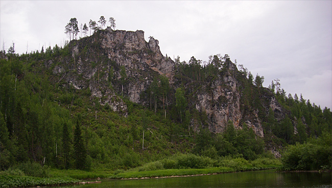
Springstone. Koiva alamjooksu kõrgeim ja võimsaim rannikujärsak.
See koosneb mitmest kaljuharjast, mis tõusevad sakiliste astmetena jõe kohal. Kogukõrgus jõe veetasemest ulatub 150 meetrini ja pikkus piki jõge ületab 1 km.
Kirjeldatud geoloogilises aruandes A.A. Krasnopolsky: "Järgmisel järsul kaljul paremal kaldal on näha terveid klappe täis kihte - Spring Stone, mis koosneb... hallist lubjakivist mustade tulekiviga sõlmedega."
Oma nime sai ta selle jalamilt voolava sügava karstijõe järgi. “Kevad” - “põhjavee loomulik väljavool maapinnale”, “võti”. Mõistet "kevad" - "võti", "allikas" märgitakse 15. sajandi vene monumentides, mis on moodustatud verbi "sünnitama" juurest sufiksiga -nik.
 Kevadkivi
 Lothari. Tänapäeval nimetatakse seda pikka ja kitsast kividega lagendikku Koiva paremal kaldal, mis ulatub Kevadkivist Ülem-Tšastoi saarteni. Kuni eelmise sajandi 50. aastate keskpaigani asus sellel eriasukate Lothari asula. Küla on ammu kadunud, aga nimi jääb.
19. sajandi lõpul kandis niimoodi hoopis teistsugune koht: kiviste paljanditeta mägi Koiva paremkaldal ja mida kirjeldas väga üksikasjalikult geoloog A.A. Krasnopolsky: "Need lubjakivid, mis on üsna sarnased devoni Vilva, Vizhay jt lubjakividega, ulatuvad piki kaldaid kuni nn Lotarini, kus need asenduvad halli kiltkivikillustiku, halli ja punase saviga, mille hulgas on rauamaardlate uurimist alustati 1865. aastal maagi... Selle maardla arendustööd viidi läbi mitmel korrusel... Nimetus põhineb kaevanduse avaja hüüdnimel: “lodar”, “lothar”, “lotyr”. ”, „lodar”. Peamine tähendus on "lõõsk", aga ka "ühendusvarras", "tramp", "mõtleja", "lõbustaja", "kulukas", "poiss".
Puškin. Eraldi kivi Kevadkivi paljandites. Asub kaldakalju allavoolu osas, kaljupaljandi tippu viivast rajast paremal.
 Rock Puškin
 Kaasaegne nimi on metafoor, mille turistid annavad kaljule selle sarnasuse tõttu ühes oma käsikirjas poeedi portreega.
Vaateplatvorm. Eraldi pankrannik Kevadkivi paljandites. Tasase metsase tipuga kivine kaljujärsak, mis laskub jõe poole pika puudeta seljandikuga. Asub kaldakivi allavooluosas.
 Kevadkivi ja Koiva jõe panoraam
 Tänapäevane nimi on metafoor. Kalju lamedalt tipult - kalju tipul asuvalt “vaateplatvormilt” avaneb panoraam kogu Kevadkivist ja selle jalamil voolavast Koivast. Nimi põhineb tegusõnal "vaatama" - "suunama pilku nägema...", "vaatama".
 Koiva panoraam
 (foto tehtud vaateplatvormi kaljult)
Kilpkonn. Eraldi kivi Kevadkivi paljandites. See asub rannikukivi keskses, kõrgeimas osas.
Kaasaegne nimi on turistide antud metafoor kivipaljandi sarnasuse kohta selle kahepaikse roomaja peaga.
 Kivikilpkonn
 Shakerid. Mitmed vertikaalsetest lubjakivikihtidest koosnevad kaljud. Need ulatuvad mööda Koiva mõlemat kallast Sukhoi jõest Lotharinsky Sukhodolini.
 Scala Vostryaki
 Vostrjakke kirjeldab üsna värvikalt A.A. Krasnopolski: “Kohe Suhhaja suudme taga Koiva paremal kaldal kõrguvad kõrged kaljud, nn “Vostryaki”, hallist tihedast... lubjakivist... Koivast alla... vertikaalselt püsti Nende lubjakivide kihte on täheldatud Koiva vasakkaldal, pealegi ulatuvad need vertikaalsete mäeharjade või müüritena jõkke, andes sellele Koiva kaldaosale üsna maalilise ilme.

 Vostryaki kaljud
 Geograafiline nimetus põhineb võrdleval metafooril, mis on seotud rannikukaljude struktuuriga. “Vostryak” - “mäetipp”, “mägede terav tipp”, “terav mägi”. Mitmuses kasutatakse sõna "segamine". "Vostry" tähendab "terav".
 "Heraklese sambad"
 Jõepõhjas 1,5-2 m kõrgune kiviplaatidest hari.
Pužnõi kivi. Kõrge ja võimas kivipaljand paremal kaldal, 1 km Pochta trakti all. Koosneb kahest osast. Ülemises osas on üksildane kuni 40 meetri kõrgune kolmnurkne kivi. Allpool järsu vasakpöörde ümber avaneb peamine kivimassiiv. Järskude kaljude kõrgus ületab 100 meetrit ja pikkus ulatub 1 km-ni.
 Puzhny kivi
 Aruandes mainis A.A. Krasnopolski: "Jõe väikeses kirdekäärus, selle paremal kaldal, moodustavad need hallid lubjakivid... suured kivid... Puženõ."
Biserski ja Kusje-Aleksandrovski tehaste “raudkaravanide” parvetamisel kasvas see ootamatult jõe järsu vasakpöörde taha, hirmutades lodja sarikad oma järsu ja suure mahuga. Kivi nimi pärineb vanast venekeelsest tegusõnast “ehmatama” - “hirmutama”, “kartma, kartma”, “hirmu sisendama, hirmu”, “ähvardama”, “ähvardama”.
Korobeyka. Väike kolmnurkne kalju, mille jõest paistab väike koobas. See asub vasakul kaldal, Pužnõi kivi keskosa vastas.
Kalju kirjeldas A.A. Krasnopolsky: “Natuke madalamal, vasakul kaldal valged peeneteralised lubjakivid... moodustavad üsna ilusa kalju “Peddler”. Kaasaegne nimi on "Korobeyka". Nimetus põhineb võrdleval metafooril: kalju struktuur koos koopaga meenutab kasti.
“Korobeyka” - Permi murretes tähendab “karp”, “korv”.
 Korobeyka
 Perevoloka Koiva vasakul kaldal asuv mäehari, mis moodustab umbes 3 km pikkuse peaaegu suletud jõesilmuse ja lühikese 200 m laiuse.
Mäe nime mainib A.A. Krasnopolski. Permi piirkonnas on mõiste "transport" üks tähendusi "jõekäänakute vahel asuv maakits, mida mööda paate veetakse teekonna lühendamiseks". Geograafiline nimetus "perevoloka" - "jõgedevaheline ruum, mille kaudu laevu edasiseks navigeerimiseks lohistatakse" on märgitud 12. sajandi vene monumentides, mis moodustati eesliitega per - verbi "voloch" juurest - "lohistada". ", "kanda midagi ilma seda maa küljest lahti rebimata."
Ülemine Perevolochny kivi. Kivine paljand-sein Perevoloka mäe alguses, millel on tugev surve vasakule kaldale.
Esmakordselt kirjeldas A.A. Krasnopolsky: “5,5 versta suudmest kõrgemal moodustab Koiva aasakujulise käänaku, kõverdunud lääne poole. Selle käänaku alguses, Koiva vasakul kaldal Perevoloka mäel paljanduvad valged paksukihilised peeneteralised lubjakivid.»
 Ülemine Perevolochny kivi
 Nižni Perevolochny kivi. Jalamil niššiga kivine kalju. Asub vasakul kaldal silmuse lõpus.
 Nižni Perevolochny kivi
 Mainitud on ka A.A. Krasnopolsky: "Selle käänaku lõpus, Koiva vasakul kaldal, kohtame taas lubjakivisid, mida nägime juba Perevoloki mäel." Nimed on paarikaupa.
Loodusobjektide asukoha selgitamiseks kasutatakse omadussõnu “ülemine” ja “alumine”.
Kurtym Stones. Koiva paremal kaldal on kaks kõrget kivist seljandikku. Need kõrguvad selle sängist kaugele alla Kurtõmka jõe ühinemiskoha.
Oma nime sai see lisajõe järgi.
Ristleja. Kurtõmi kivide esimene hari. See on kolmnurkse kujuga lameda tipuga ja kuni 100 meetri kõrgune kaljupaljand.
 Ristleja
 Tänapäevane nimetus on turistide antud metafoor: jõelt vaadates meenutab kalju kõrget laevavööri, mis lõikab läbi segametsa rohelisi “laineid”.
Sinine kivi. Viimane, väga maaliline rannakivi. Asub Koiva vasakul kaldal, 1 km enne selle ühinemist Tšusovajaga.
 Sinine kivi
 Kalju nimi on mainitud aruandes A.A. Krasnopolsky: "Ja lõpuks avastatakse Ust-Koiva küla lähedal Siny Kamenis vasakul kaldal hallid lubjakivid."
Vastavalt E.M. Pospelova: "Seda vene folklooris levinud nime seostatakse silmapiiril olevate siniste mägede visuaalse muljega." Seda kinnitavad kohalike elanike jutud: "Selle piirjooned on selge päikesepaistelise ilmaga nii hommikul kui ka õhtul sinisesse udusse uppunud."
 Sinine kivi
 Taimed pakuvad meile enamat kui lihtsalt toitu, varju või silmailu. Nad on ka looduslik apteek, mis on võimeline ravima paljusid haigusi ja kinkida meile täiskõhutunnet ja elurõõmu paljudeks aastateks.
 pune (origanum vulgaris L.)
Oregano ladinakeelne nimi tuleb ladinakeelsetest sõnadest: oros - mägi, gamus - kaunistus; mäe kaunistus. Venemaal on taim levinud peaaegu kõikjal, välja arvatud Kaug-Põhjas. Koloniseerimiseks valib pune kuivade metsade raiesmikud, nende servad, kõrgendikud ja lamminiidud ning kuivad lagedad kivised kohad. Ürdi lõhn on meeldivalt aromaatne, maitse mõrkjas-vürtsikas, kergelt kokkutõmbav, hapukas.
Rhodiola roosa(Rhodiolarosea L.) on üks kuulsamaid ravimtaimi. Kuid paljud inimesed tunnevad Rhodiola populaarseid nimesid - "kuldne juur", "Siberi ženšenn".
Vana Altai uskumus ütleb: kes leiab kuldjuure, on õnnelik ja terve elupäevade lõpuni ning elab kaks sajandit.
Hiina keisrid varustasid kuldjuure otsimiseks spetsiaalsed ekspeditsioonid. Suurima väärtusena toimetas see taim salakaubavedajate poolt üle piiri.
Altai põlisrahvas peitis hoolikalt kohti, kus kuldjuur kasvas. Selle kasutusviise ümbritses salapära, mis kandus isalt pojale ja läks vahel koos omanikuga hauda.
Kuldjuure ümber tekkisid legendid – üks värvilisem kui teine.
Teadlaste eriekspeditsioonid, kes läksid kohtadesse, kus legendi järgi kasvas kuldjuur, naasid ilma milletagi. Teadmata, milline see taim välja näeb, möödusid botaanikud sellest mööda.
Alles 1961. aastal toimus ekspeditsioon, mida juhtis professor G.V. Krylov leidis kuldjuure Altai taigast, 3000 m kõrguselt.
Rhodiola rosea uuringud on näidanud, et see on lihtsalt kasulike ainete ladu. Taime juured sisaldavad eeterlikku õli, parkaineid, üle 20 väärtusliku mikroelemendi (raud, fosfor, magneesium, mangaan, antimon jt), askorbiin- ja nikotiinhapet. Rhodiola lehed ja varred sisaldavad õun- ja viinhapet.
 Rhodiola rosea (Rhodiolarosea L.)
Rhodiolarosat on ravimtaimena kasutatud juba ammusest ajast.
Perekond Saxifraga perekonnast Saxifraga (Saxifragaceae) on üsna arvukas, selles on üle 450 liigi mitmeaastaseid rohttaimi.
Taimed erinevad oluliselt lehtede ja õite suuruse, kuju ja värvi poolest ning erinevad üksteisest oluliselt elutingimuste nõuete poolest. Nad elavad põhja- ja lõunapoolkera külma ja parasvöötme piirkondades, samuti mägismaal. Neid võib leida tundras, arktilistes kõrbetes, metsavööndites ning alpi- ja subalpiinsetes mägipiirkondades.
 Saksifrage (kivide purustamine)
Jõe nimest on kaks versiooni. Esimese järgi, tõlgituna komi-permjaki keelest, on “koi” pritsmed, “va” on vesi. Seetõttu tähendab Koiva “pritsivat vett”. Teine versioon on mansi päritolu, selle järgi tähendab nimi "hele jõgi".
Jõe kirjeldus
Permi territooriumil asuv Koiva jõgi on oluline jõgi, mis voolab Uurali aheliku, parempoolse Tšusovaja jalamil. See pärineb traktist, mida nimetatakse Blue Swampiks, Bolšaja Khmelikha mäestiku moodustisest. Kõigepealt voolab see edela suunas Malaya Voronka jõe suudmeni. Seejärel pöördub see põhja ja suubub Biseri jõe suudmesse. Seejärel pöördub see läände, ühinedes Tšusovaja jõega, mis asub 66 kilomeetri kaugusel selle suudmest. Jõe pikkus on 180 kilomeetrit, hõivatud ala 2250 ruutkilomeetrit, ülevoolu keskmine kõrgus 359 meetrit, kalle umbes poolteist meetrit 1 kilomeetri kohta.
Peamised lisajõed: vasakul kaldal - Tiskos, Olhovka, Tyrym; paremal pool on Biser, Saranka, Kusya jõed.
Jõe lähtest umbes 90 km kaugusel paremal kaldal asub Biseri küla. Selle ehitas 1786. aastal vürstide Šahhovski perekond ja müüdi hiljem krahvidele Šuvalovitele. Siin oli samanimelise Biseri jõe ääres suur tehas. Selle blokeerib suur tamm, mis ulatub ligi kümne meetri kõrgusele ja ligi poole kilomeetri pikkusele. See moodustas suure ja ilusa tiigi, mis oli korraliku järve mõõtu. Tammi ülevool on kaskaadne ja puidust astmetest. See on üsna muljetavaldav struktuur. Tehas pole säilinud, see lasti õhku kodusõja ajal.
Olles Koivast allavoolu, Biserist umbes 30 kilomeetri kaugusel, satuvad reisijad ja turistid kuulsa kaheastmelise Fedotovski kärestikku.
Veel allavoolu, Bolšoi Tyrymi jõe suudmes, asub Ust-Tyrymi asula. Pärast seda algavad Kova mõlemal kaldal majesteetlikud kaljud. Kõige muljetavaldavam neist on sünge 70-meetrine kivi, mida nimetatakse "võitlejaks Shaitaniks", mis asub jõe paremal küljel.
Allavoolu on suur Kusye-Alexandrovsky küla. Küla nime andis 1751. aastal krahv Aleksandr Stroganovi ehitatud tehas. See tehas tootis mitmesuguseid metallurgiatooteid, sealhulgas valati kahurikuule. Tooted toimetati parvedega mööda Koiva jõge Tšusovaja jõkke.
20. sajandi alguses ulatus küla elanike arv 2500 inimeseni. Kuid kodusõja ajal lasti tehas õhku ja seda enam ei ehitatud. Külas asuv tehasetiik on väike. Ülevoolutee on 4-meetrine juga. Suurveeperioodidel, kevadel ja suve alguses hüppavad ekstreemspordihuvilised sellelt katamaraanidel. 20. sajandi keskel oli küla NSV Liidu teemandikaevandustööstuse keskus. Selles asus Uralalmazi juhtkond.
Kalapüük Koival
Kalurite hinnangul on kalu oluliselt vähem. Sealhulgas seetõttu, et kohalikud elanikud kuritarvitavad võrke nende püüdmisel. Harjust on siiski võimalik püüda. Kohtad täkke, haugi, ahvenat, võsa ja märksa harvemini - särge ja ide. Talvel elatuvad nad takja püüdmisega. Vanad inimesed räägivad, et Koiwe jões kalapüük andis varem taimenit, kuid selle kohta pole andmeid, et see praegu siin elaks.

Parvesõit Koiva jõel, Permi piirkonnas
Reisijatele ja sportlastele meeldib veeta aega jõel parvetades. Siiski on puudus - hooajaline madal vesi. See lõpeb maikuus, hetkel, mil jõe kaldaid kaunistavad õitsevad linnukirsipuud.
Parimaks raftinguvõimaluseks suvel peetakse 180 km pikkust marsruuti. See pärineb Teplaya Gora küla vanast maanteesillast. Marsruut lõpeb seal, kus Koiva jõgi suubub Tšusovaja jõkke, Ust-Kove külas. Soovijad saavad teekonda jätkata, sõites mööda Tšusovaja jõge samanimelisse linna. Kõigis Koiva kaldaäärsetes asulates on mugavad ligipääsud veehoidlatele ning veesõidukite kogumiseks on kohti.
Parvetamise esimesi kilomeetreid peetakse kõige raskemaks. Nendes kohtades iseloomustavad Koivat kiired hoovused ja looklevad käänakud. Hiljem muutub kanal laiemaks ning kaldaid eristavad kaunid kivid ja kaljud. Marsruudil tuleb kindlasti läbida tamm, veesõidukit maale lohistades. Koiva jõgi on parvetamiseks väga huvitav. Seda seletatakse eelkõige kaunite kallaste ja selle ettearvamatusega, mis on seotud kitsa kanali ja kiire vooluga. Koiva jõel tehtud fotod on alati ainulaadsed ja muljetavaldavad.
Kuidas sinna saada?
Inimesed jõuavad tavaliselt autoga mööda jõge sõitmise alguspunktidesse, nimelt jaama. Teplaya Gora, küla. Vanad helmed või Kusye-Alexandrovskoe. Tuleb arvestada, et teed jätavad soovida, nende kvaliteet on madal. Need, kes soovivad raftingut läbi viia, sõidavad tavaliselt rongiga, marsruudil Nižni Tagil - Chusovaya või Jekaterinburg - Solikamsk. Jaama, kus saab maha tulla: Teplaya Gora, Ust-Tiskos, Biser või Pashiya. Biseri ja Pashiya küladest Old Biseri ja Kusye-Alexandrovskyni viivad kohalikud bussiliinid kohtadesse, kust saab raftingut alustada.
(Uurali seljandiku läänenõlval).
See voolab edelast Malaya Voronka jõe suudmeni, seejärel põhja Biseri jõe suudmeni ja siis läände. Suubub suudmest 66 km kaugusel Tšusovajasse. Koiva pikkus on 180 km, basseini pindala 2250 km2, valgala keskmine kõrgus 359 m, keskmine kalle 1,5 m/km.
Koiva jõgi
Peamised lisajõed:
vasakult: Tiskos, Kyrma, Olhovka, Tyrym;
paremal: Biser, Saranka, Kusya.
Koiva on valdavalt mägine jõgi, käänuline ja kiire, rohkete müra ja madalikuga. Kallastel on okasmetsad ja seal on kive - "võitlejaid".
Mais-juunis kasutavad seda turistid parvetamiseks Tyoplaya Gora külast Chusovskaya jaama. 
Koiva on Tšusovaja väike maaliline lisajõgi. Jõe ainsaks oluliseks puuduseks on madal veetase madalveeperioodidel, kuid mais, eriti linnukirsi õitsemise ajal, võib Koiva jätta reisijatele kustumatu mulje.
(aga need on tõelised kristallripatsid) - Põhja-Uuralid 
Purjetamist mööda Koyvat saab alustada Tšusovoi-Kušva teelt Teplaya Gora jaamast, kus jõgi on vähem kui 1 km kaugusel (teine võimalus stardipaigaks on Kushva kõrval asuv Ust-Tiskose jaam, kust on ca. 2 km edasi kuni Koivu raudteesillani, kuid Teplaya Gorast on võimalik mööda minna madalaveelisest 12-kilomeetrisest jõelõigust). 
Marsruudi alguses voolab Koiva - kiire, laineline, käänuline 15-20 m lai ja mitte üle 1 m sügav jõgi - mööda järske kaldaid mööda kitsast sügavat orgu, mille nõlvad on kaetud okasmetsaga, sageli koos vette viivate rannikualade lepa ja linnukirsipuudega . Jõe käänakutel paljastavad erodeeritud kaldad tumedad kivikaljud. Edasi laieneb jõeorg, jäädes metsaseks, kuid siis Biseri küla lähedal (kilomeetrise lõhega silla piirkonnas) kaunistavad kaldad taas kividega.
(lumine hommik Kesk-Uuralites) Koiva jõgi 
Kusye-Alexandrovsky külla on kõige maalilisem ja hõredamalt asustatud jõelõik. Siin peate ületama mitmed kivised lõhed ja kesklinnas läbitava Fedosovski läve; Koiva laius on 25 - 30 m, kallastel on kaunid dolomiidist kivid ja kaljud.
(Koiva suudme - edasi Tšusovaja jõgi) 
Pärast Kusje-Aleksandrovskit on jõel tamm, mis tuleb ümber piirata. Sellel alal ja kaugemal, peaaegu suudmeni, voolab Koiva kõrgetel kivistel metsaga kaetud kallastel, kuid siin on jõesäng süvendatud. Viimastel kilomeetritel enne Tšusovajasse suubumist on Koiva vool kiire, ühele järgnevad sahinad ja pöörded. teise järel.
(iidne Uurali vulkaan)
Vastupidiselt kitsale kiirele Koivale tundub rahulik Tšusovaja, mille laius siin ulatub 100 meetrini, esialgu väga lai. 34 km pärast ühinemist lõpeb reis Chusovoy jaama lähedal.
Allikas: Voronov Yu.B. " 100 lemmikmarsruuti süstamatkadeks". M., "Mir", 1993.
Koiva jõgi 
KOYVA JÕEST
Koiva voolab läbi maaliliste paikade – okasmetsaga kaetud järskude kallaste vahel. Ülemjooksul kuni Biseri külani koosnevad kivised kaldad tumedatest kildadest ja diabaasidest, seejärel - lubjakividest ja dianiitidest ning alamjooksul liivakividest.
Koiva jõge võib asulate arvu ja muinasaja poolest nimetada Gornozavodski piirkonna kõige asustatud, tööstuslikumaks ja ajaloolisemaks jõeks. Suurimad külad on: Teplaya Gora, Biser, Kusye-Alexandrovsky. Viimase asustus kasvas, kui Kusja jõe suudmesse rajati 1751. aastal rauasulatus- ja rauatehas. Kusye-Aleksadrovsky on piirkonna vanim ja suurim küla.
Kevadise üleujutuse ajal muutub Koiva, nagu iga mägijõgi, tormiseks ojaks, kus on sassi, kärestikku ja lõhesid. Eriti kuulus on Fedotovski kärestik, mis asub Fedotovka jõe suudme lähedal, see on üle jõesängi asetsev tohutu kiviplaat, mille keskel on võimas ülevool.
Peaaegu kogu jõe pikkuses kõrguvad kaunid kaljud, mille järskudes müürides on grotid ja koopad. Umbes mõne kilomeetri kaugusel Ust-Tyrymi külast asub jõe kõrgeim kivi – Shaitani kivi.
Kusye-Alexandrovsky küla lähedal muutub jõgi laiemaks ja rahulikumaks. Paremal suubub Kusya jõgi kolmemeetrisesse juga. Jõele tekib tiik, mille tammist kukub Kusja koesse Koivu. Küla taga, keset Koiva jõesängi, on saared - siin oli sõjajärgsetel aastatel süvend, nendes kohtades kaevandati teemante. Nüüd on saared aga puudega võsastunud ja jätavad loomuliku mulje. 20 kilomeetri pärast suubub Koiva paremalt Tšusovajasse. Jõe suudmes vasakul kaldal asub Ust-Koiva küla.
KÜLA TEPLAYA MÄGI
Tyoplaya Gora on linnatüüpi asula Venemaal Permi oblastis Gornozavodski rajoonis.
Vene Föderatsiooni valitsuse 29. juuli 2014 korraldusega nr 1398-r „Ühetööstuslike linnade nimekirja kinnitamise kohta“ on linn lisatud kategooriasse „Vene Föderatsiooni ühe tööstusega omavalitsused (monolinnad). ) kõige raskema sotsiaal-majandusliku olukorraga.
Asub Kesk-Uurali läänenõlval Teplaya mäe lähedal Koiva jõe ääres (Tšusovaja lisajõgi), umbes 14 km läänes Permi territooriumi ja Sverdlovski oblasti ning Euroopa ja Aasia piirist. Raudteejaam asub Tšusovoi linnast 113 km kirdes, Permist 244 km, Moskvast 1678 km kaugusel.
Lugu
1880. aastal alustas krahv Šuvalov Teplogorski rauatehase ehitamist. Ilmselt tekkis esimene asula veidi varem. Küla võlgneb oma nime järgmisele legendile. Küla asub mäe nõlval, all Koiva jõe ja üleval raudtee vahel. Kaubaga raudteejaama jõudmiseks pidid vankrid (ja lasti, nagu teate, hobustel) ronima selle mäe otsa. Mäkke roninud, isegi talvekülmas, pühkis nad otsaesiselt higi ja ütlesid: "Vau, kui soe mägi!"
1912. aastal püstitati siia esimene ja tollal ainuke elliptilise profiiliga kõrgahi Venemaal.
Külast mitte kaugel leiti 1829. aastal esimene teemant Venemaal, kulda kaevandatakse tööstuslikult ja plaatinamaardlaid on väikeses koguses.
Enne Gornozavodskaja Uurali raudtee ehitamist 1879. aastal ujutati kõik Bisera tehaste, aga ka Tyoplya Gora, Kusje-Aleksandrovski valmistoodang praamidel mööda Koivat ja Tšusovajat Kamasse.
1956. aastal muudeti tehas valu- ja mehaaniliseks tehaseks.
Alates 1987. aasta detsembrist alustas tööd killustikutehas.
Küla läbib Perm-Nižni Tagili raudtee, mis on ühtlasi ka Sverdlovski oblastist põhja poole suunduv peamine maantee Serovi ja Severouralski linnadesse.
Uus asfaltbetoonkattega tee ehitati ühes suunas Tyoplya Gorast Gornozavodskisse ja teises suunas Sverdlovski oblastisse Kachkanari (Promysla küla kaudu). Ehitati Permi-Jekaterinburgi maantee, mis läbib Polazna, Chusovoy, Tyoplya Gora, Promysla, Kachkanar.
Turism
Tyoplaya Gora jaam on turistide jaoks oluline transpordisõlm. Turistid läbivad selle raftingul Permi oblasti jõgedele: Usva, Koiva, Vilve jne või jalgratta- ja matkamarsruutidel Tyoplaya, Kolpaki mägedesse ja edasi Sverdlovski oblastisse jm.
CHUSOVOY LINN
Tšusovoi on linn Venemaal, Permi oblasti idaosas Tšusovski rajooni ja Tšusovski linnaasula halduskeskus.
Vene Föderatsiooni valitsuse 29. juuli 2014 korraldusega nr 1398-r „Ühetööstuslike linnade nimekirja kinnitamise kohta“ on Tšusovskoje linnaasula lisatud kategooriasse „Vene Föderatsiooni ühe tööstusega omavalitsused“. (monolinnad), kus on kõige raskem sotsiaalmajanduslik olukord.
Linn asub Permist 140 km kaugusel, Usva ja Vilva jõgede ühinemiskohas Tšusovaja jõkke, laias orus, mida ümbritsevad mäeharjad, mis üsna sügavalt sisselõikelise oru tõttu on üsna järskude nõlvadega. Pindala 58,0 km².
Linn asutati 1878. aastal. Tšusovoi tekkimist seostatakse Gornozavodskaja raudtee ehitamisega 1878. aastal Tšusovskaja jaamana ja metallurgiatehase rajamisega 1879. aastal Prantsuse ettevõtjate poolt (esimene kõrgahi ehitati 1894. aastal).
Tšusovaja jõe ületava maanteesilla ehitamisega 1964. aastal alustas linn intensiivset elamuehitust jõe vasakul kaldal. Selle tulemusena laiendas linn oluliselt oma piire. Tšusovaja jõe vasakul kaldal Uuslinnas on rajatud mikrorajoonid A ja B ning käimas on mikrorajooni B ehitus.
Linna sotsiaalse infrastruktuuri arendamine toimus kõige intensiivsemalt 50ndatel ja viimastel aastakümnetel. Haridussüsteem on arenenud. Praegu on linnas 8 põhikooli (1.-9. klass), gümnaasium (1.-11. klass) ja üks kool keskkooliõpilastele (ehitatud piirkondliku eksperimendi raames), veel 16 kooli tegutseb Tšusovski munitsipaalrajoonis. Koolieelseid lasteasutusi on 25 (linnas 18 ja piirkonnas 7), lisaõppeasutusi 3. Lisaks on Tšusovois meditsiinikool, tööstustehniline kool, kutsekool ja USTU UPI oma nime saanud filiaal. B. N. Jeltsin. Spordikompleksi Ogonyok baasil asub olümpiareservi spordikool (kelgutamine, freestyle, loodussuusatamine, mäesuusatamine).
Kultuuriasutusi esindavad metallurgide kultuuripalee, kaks kino, raudteelaste kultuurimaja, viis raamatukogu ja muusikakool. Uuslinnas on linnapark. Seal on ka noorte tehnikute jaam. Ogonyoki spordikompleksis - Chusovsky etnograafilises pargis - on näitus, mis on pühendatud 19. sajandi lõpu maaelule.
Tšusovois asub vene õigeusu kiriku kogudus.
Käivitati metallurgiatehase ambulatoorium, kliinik 200 külastusega vahetuses ja haigla 150 voodikohaga. Samas on märkimisväärne puudus arstidest ja õendustöötajatest. Uuslinna on vaja kliinikut.
KOYVA JÕEST
Jõe kaldad on kaetud metsaga, asulaid on vähe. Koiva suurimad asulad on Teplaya Gora, Stary Biser ja Kusye-Alexandrovsky. Need on mugavad viskamiseks ja viskamiseks. Neist vanim ja suurim on Kussier-Alexandrovsky. Kusya ja Koiva jõe ühinemiskohas asuv rauatööstus rajati 1751. aastal.
Jõe kaldal on ilusad kivid. Need on palju tagasihoidlikumad kui väga lähedal voolavad majesteetlikud kaljud Tšusovaja jõel. Koiva on aga omamoodi ilus! Koival on turiste vähe. Parkimiskohti ja küttepuude jaoks on piisavalt.
Mööda Koivat on kõige parem parvetada suurvees – mais või juunis või pärast tugevat vihma. Suvel muutub jõgi madalaks. Eriti ülemjooksul. Kevadel sobib parvetamiseks Teplaya Gora jaamast kuni Tšusovajaga liitumiseni (samanimelisel jõel on mugav sõita Tšusovaja linna).
Suvel on parem alustada parvetamist Kussier-Aleksandrovsky juurest. Kuid ka siin tuleb sageli veesõidukiga madalikul liigelda. Siin-seal Koival võttis võimust tragi, jättes maha kaevatud jõesängi ja saared.
Parvetamise marsruudil mööda Koiva jõge on mitu võimalust. Siin on asulad, kust saate marsruuti alustada ja selle lõpetada: Teplaya Gora - Ust-Tiskos - Stary Biser - Kusye-Alexandrovsky - Ust-Koiva - Chusovoy linn (Chusovaya jõgi).
Marsruudi kogupikkus Teplaya Gorast Chusovoy linna on umbes 180 kilomeetrit. Kevadel kiirete hoovustega saab kogu marsruudi Teplaya Gorast Chusovoyni läbida kolme-nelja päevaga.
Lõigus Teplaya Gora jaamast kuni Ust-Tiskose jaamani voolab Koiva raudtee lähedal umbes 8 kilomeetrit. Raudteel reisides (lõik Tšusovskaja - Nižni Tagil) võite alustada raftingut ükskõik kummast jaamast (teplaya Gorast on aga tee jõeni palju lähemal).
Kusja-Aleksandrovskis on huvitav Kusja jõe suubumine Koivu juga. Mõned ekstreemsed veeturistid läbivad selle drenaaži katamaraanidel. See on üsna ohtlik ja nõuab palju kogemusi.
Pärast Kusye-Alexandrovsky küla muutub jõgi laiemaks, täidlasemaks ja rahulikumaks. Kuigi ka siin on probleemseid piirkondi.
Lisaks kiiretele kärestikele on Koival kärestikud ja lõhed. Eriti head on Fedotovski kärestik ja Kalistratovskaja värin (mõlemad vaatamisväärsused on Stary Beadsi ja Kusye-Aleksandrovsky vahel).
Fedotovski lävi ei kujuta endast erilist ohtu, kuid algajad peaksid selle hoolikalt läbima. Fedotovski kärestike pikkus on umbes 500 meetrit.
Varem asus selle läve lähedal Fedotovka küla. Nüüd on sellest järel vaid raiesmik, läve ja trakti nimi kaardil.
Hüdroloogia
Veesüsteem: Chusovaya → Kama → Volga → Kaspia meri.
Pikkus: 180 km.
Valla pindala: 2250 km².
Kalle: 1,9 m/km.
Voolu iseloom: Piemonte.
Lisajõed: Bolšaja Šaldinka, Poludenka, Pesjanka, Tiskos, Kyrma, Bolšaja Voronka, Biser, Bolšaja Saranka, Malaja Saranka, Malaja Uraika, Bolšaja Uraika, Bolšaja Tõrõm, Kusja, Jamskoi Log, Kurtõmka.
Veehoidlad: Medvedkovski tiik.
Põhi: kivine, kohati kivine.
Geograafia
Rannikumaastik: jõgi voolab hajaasustusalal, okas- ja segametsadega võsastunud madalate mägede vahel. Kallaste ääres on sageli kiviseid paljandeid, kohati on järved ja märgalad.
Kallaste asulad: Medvedka, Promysla, Tyoplaya Gora, Ust-Tiskos, Stary Biser, Ust-Tyrym, Kusye-Alexandrovsky, Ust-Koiva
Allikas
Koordinaadid: 58°49′59,1″ N. laiuskraad, 59°02′19,5″ e. d.
Kõrgus merepinnast: 463 m.
Topograafiline maamärk: Sinine soo, mis asub Bolšaja Khmelikha mäe kirdenõlval.
Suudmeala
Koordinaadid: 58°13′56″ põhjalaiust. laiuskraad, 58°12′09,8″ e. d.
Kõrgus merepinnast: 127,4 m.
Asukoht: Tšusovaja jõgi - parem kallas suudmest 66 km - Ust-Koiva küla piires.
Marsruut: populaarseim Koiva raftingu marsruut algab Tyoplaya Gora külast ja jätkub kuni suudmeni. Seejärel jätkavad turistid tavaliselt parvetamist mööda Chusovaya - Chusovoy linna.
Raskusaste: 2.
Takistused: kiired hoovused, surved, kärestikud, lõhed, vees lebavad puud.
Kalapüük Koiva jõel
Kalade tüübid:
ahven
ahven
ruff
ruff
Demoiselle minnow
Demoiselle minnow
nänn
nänn
sünge
sünge
särg
särg
dace
dace
tükike
tükike
ide
ide
Euroopa harjus
Euroopa harjus
haug
haug
burbot
burbot
Püügikohad
Edukas kalapüük on võimalik Medvedka külast ja allavoolu.
Kalapüügi omadused
Kohalike kalurite sõnul on jõgi rikas harjuse poolest, siin püütakse sageli ka haugi ja ahvenat. Harvemini esineb püügis särge ja särgi. Talvel on võimalik takjapüük. Samuti on andmeid, et sellest jõest püüti varem taimeneid, kuid viimasel ajal pole sellest midagi teada.
Koiva ülemjooksule
Ilm Permis oli endiselt kuiv ja soe. Kuivatasime ja tegime korralikult sooja. Pärast kaardiga konsulteerimist otsustasime minna turistide ja kalurite seas kuulsa Chusovaya jõe basseini. Minu jaoks on sellega reisimine olnud ammune unistus. Nüüd avanes selline võimalus.
Otsustasime purjetada mööda Koivat, olles eelnevalt sinna jõudnud Nižni Tagili suunduva rongiga. Koiva pärineb Uurali seljandiku päris keskelt, suubudes edelas Tšusovajasse. See ei tähenda, et Koiva oleks metsik jõgi, 170-kilomeetrisel parvematkal sattusime alamjooksul kolmele külale ja mitmele turistiparvele.
See on miniatuurne Vishera, kus on mitte nii suurejoonelised, kuid mitte vähem kaunid kivised alad, hea voolukiirus ja tihedad metsad, mis on täis seeni ja marju. Ilm on siin palju pehmem ja soojem kui Visheras ning arvukad madalad madalad lõhed võimaldavad kerge spinningu ja lendõngega püügi austajatel rahulikult mööda seda hõljuda.
Kalapüük Visheral ja Koival Peaaegu igal pool saab kõnnib püssi keskele ja kärbse või lusikaga auku visata, nii et siin on täiesti võimalik komistada hea haugi või ahvena otsa või püüda 200-grammist harjust. .
Väikese laiuse tõttu esineb Koiva ülemjooksul kohati ummistusi, kuid kõik need on ühelt või teiselt poolt läbitavad. Harjus on ettevaatlik ja püütakse väikeste kuivade kärbestega suurte kividega pikkade kaljulõhede juurest ja millegipärast vees seisvate takjaste tihnikute juurest. Tõenäoliselt jääb see siia ämblike ja muude taimedelt kukkuvate putukate tõttu.
Koivas on vett päris palju - paistab, et ka siin oli nädal tagasi tugevat vihma. Seda on näha veepinnast 1,5 m kõrgusel okstel rippuvast võsast ja kalda lähedal veel vee all olevatest takjastest. Kala hammustab ettevaatlikult ja vastumeelselt. Peate jälgima, mida ta sööb, ja veetma pikka aega kärbseid korjates.
Teised raftingul osalejad kaevasid mädanenud prahi alt vihmausse ja hakkasid nendega datse püüdma. Kalasuppi muutsid mitmekesisemaks vaid paar aeglasest jõest püütud harjust ja ahvenat. Püügisurvet on tunda. Ma pole küll näinud, et ükski parvega turist oleks siin lantidega harjust püüdnud, aga haugi püütakse vahel liikvel.
Terve tee mööda Koivat kohtasime vaid üht võimsat kärestikku - Fedulovskit, siis olid Tšusovajaga liitumiskohast mõne kilomeetri kaugusel vaid väikesed kõrge kaldega kärestik. Tähelepanu ei tasunud aga kaotada ka toona - ühel äravoolul sattus meie kõige hoogsam paat ikkagi pärast püssist äravoolu tekkinud tugevasse vastutulevasse keerisesse ja kühveldas küljega poole paadi veest. Kõik kuivatati kaldal, aga see oli tänuväärne kogemus.