
Beautiful places in Karelia. Natural climbing walls of Karelia Tour additions
The Republic of Karelia is located in Northern Europe, on the border between Russia and Finland. It is called the center of wooden architecture, the pantry of mushrooms and the most mysterious region in Russia. Many beautiful photos were taken here, but they are not able to convey the whole gamut of feelings that these places evoke in the traveler. Fabulous taiga forests, transparent lakes, virgin nature, an abundance of historical and architectural monuments - all this must be seen with your own eyes.
Mount Vottovaara
In the central part of the republic, 20 kilometers southeast of the village of Sukkozero, there is a curious place - Mount Vottovaara, the highest peak of the West Karelian Upland (417 meters).
Locals call this place of power Death Mountain and consider it a portal to other world- here an anomalous effect on electrical equipment, nature, and the human body is noted. The dead silence, as well as the depressing sight of trees bent, broken by the wind and blackened after the fire, enhance the ominous feeling.
In 1978, a complex of ancient cult seids was discovered on the mountain - stones-boulders of a run-in form, located in groups. At the same time, huge blocks lie on smaller ones, creating the impression of stones on legs.
Also on Vottovaara there is a mysterious staircase to the sky - 13 steps carved into the rock, ending in an abyss.
Mount Kivakkatunturi
It is located in the Paanajärvi National Park, in the Loukhi region. The height of the mountain is 499 meters, and the name is translated from Finnish as “stone woman” – at the top there are many seids, one of which resembles the head of an old woman.
The ascent to Kivakka is quite easy and takes 1-2 hours - in addition to the trodden path, wooden beams are laid for the convenience of tourists. When climbing, you can see around the landscape features characteristic of these places - hanging swamps and high-altitude lakes lying on the slopes of the mountain and indicating the water content of the rock.
The beauty of Paanajärvi Park is clearly visible from the open top. This place becomes especially picturesque with the advent of autumn, when the plants paint the mountain in yellow-crimson colors.
Ruskeala Mountain Park (Marble Canyon)
The basis of this tourist complex in the Sortavala region of Karelia is a former marble quarry. The blocks mined here were used for facing the palaces and cathedrals of St. Petersburg and other Russian cities. Now these quarries have turned into man-made marble bowls filled with the purest water and cut through by a system of shafts and adits resembling mysterious caves and grottoes.
The mountain park is 450 meters long and about 100 meters wide. It is equipped for tourists - footpaths have been cleared, observation platforms have been created, there is parking for cars, and boat rentals. It is from the water that the most impressive views of the surrounding rocks, up to 20 meters high, open up. Also on the boat you can swim into the marble grotto and admire the bizarre reflection of water in the translucent vaults.
Marble Canyon Caves
No less curious are the mines and adits of the quarry, where you can get on a guided tour. Most of these caves were flooded, but there are also dry ones - the higher the air temperature on the surface, the more deadly cold is felt here.
For the unique acoustics, one of these grottoes is called Musical. However, Proval Cave is of the greatest interest, in the roof of which a hole 20 by 30 meters in size was formed. Another name for the Pit is the Hall of the Mountain King or the Ice Cave, it is best to descend into it during the cold season, when the 30-meter water column in the grotto is hidden under ice. Drops flowing from the arches formed numerous ice stalactites and stalagmites, the beauty of which is emphasized by the backlight.
Ruskeala waterfalls (Akhvenkoski waterfalls)
Not far from the village of Ruskeala, where the Tokhmajoki River is divided into several branches, there are 4 small waterfalls. Falling from rocky ledges 3-4 meters high, kvass-colored water foams and rumbles.
The area around is ennobled, there are wooden gazebos, a cafe, a souvenir shop. Once upon a time, the films “The Dawns Here Are Quiet”, “The Dark World” were filmed in these places, now kayaking (canoeing) is carried out along the Tohmajoki River, overcoming waterfalls.
Paanajärvi National Park
This corner of wild nature is located in the north-west of Karelia, in its most elevated part and occupies about 103 thousand hectares. The park owes its name to the unique lake Paanajärvi, which arose in the faults of the rocks, the boundaries of the park run along the line of this lake and the Olanga River.
The landscapes here are picturesque and diverse - mountain peaks alternate with gorges, stormy rivers and noisy waterfalls coexist with the calm expanse of lakes.
In the park is the highest point of the republic - Mount Nourunen. Here you can also see the Kivakkakoski waterfall - one of the largest and most powerful in Karelia.
Daylight hours in winter are very short - from the end of August you can observe the northern lights. But in summer the sun sets only for 2-3 hours - it's time for white nights.
National Park "Kalevalsky"
This park was created in the extreme west of Karelia in 2006 to preserve one of the last old-growth pine forests in Europe. On the territory of 74 thousand hectares, pines occupy about 70%, the age of many trees reaches 400-450 years.
For thousands of years, these places have been an unchanging habitat for various species of animals and plants, and the virgin beauty of the forests fascinates even now. In the park you can see many large rivers with picturesque waterfalls, deep clear lakes.
There are also several villages here - Voknavolok is considered the cradle of Karelian and Finnish cultures, where the songs of the Kalevala epic were born, many historical and cultural monuments have been preserved in Sudnozero, and Panozero is considered one of the oldest settlements in the region.
Body archipelago
It is a group of 16 small islands in the White Sea, near the city of Kem. In order to preserve the unique landscape and the diversity of flora and fauna, the state landscape reserve "Kuzova" was created here. Now there are special places for visiting tourists on 3 islands - Russian Body, German Body and Chernetsky.
In addition to the beauties of the surrounding nature, the archipelago attracts with an abundance of seids, labyrinths, ancient sites of people from the Mesolithic and Bronze Ages, and religious buildings. The islands are shrouded in many legends and are still a mystery to historians and archaeologists.
Girvas volcano crater
In the small village of Girvas in the Kondopoga region of Karelia, there is the oldest surviving volcano crater in the world, its age is about 2.5 billion years.
Previously, the full-flowing Suna River flowed here, but after the construction of a dam for a hydroelectric power station, its channel was drained, and the water was released along a different path, and now petrified lava flows are clearly visible in the half-empty canyon. The crater itself does not protrude above the ground, but is a depression filled with water.
Waterfall Kivach
Translated from Finnish, the name of the waterfall means "powerful", "swift". It is located on the Suna River and is the fourth largest flat waterfall in Europe. Kivach consists of four rapids overall height 10.7 meters, of which the sheer drop of water is 8 meters.
Due to the construction of a hydroelectric power station in this area, there was a large outflow of water, which somewhat reduced the attractiveness of the waterfall. The best time to visit this attraction is considered to be spring, when the Suna is gaining strength, feeding on melt water. In 1931, the Kivach State Nature Reserve was created around the waterfall.
Waterfall White Bridges (Yukankoski)
This waterfall, located on the Kulismajoki River in the Pitkyaranta region of the republic, is one of the highest and most beautiful in Karelia and reaches about 18 meters in height. In summer, the water in the river warms up well, which allows you to swim in it and stand under the falling streams of water.
In 1999, a hydrological natural monument "White Bridges" was established on the territory adjacent to the waterfall, the area of which is 87.9 hectares. Due to its location in the forest, away from the highway, Yukankoski is not very popular with travelers.
Martial waters
This name is given to a balneological and mud resort, as well as a village in the Kondopoga region. The resort was founded by Peter I in 1719 and is the first in Russia.
There are 4 wells from which mineral waters flow, their main feature is the amount of iron, which is greater than in other sources in Russia and abroad. In each source, the concentration of iron is different, and the waters also contain calcium, magnesium, manganese, and sodium.
Sapropelic silt sulfide muds extracted from the bottom of Lake Gabozero also have healing properties.
The resort is visited for the treatment of diseases of the blood, cardiovascular, digestive, genitourinary and musculoskeletal systems, respiratory organs. Here, according to the project of Peter I, the Church of St. Peter the Apostle was built, and opposite the temple is the building of the local history museum "Marcial Waters".
Valaam Island
The name of the island is translated as "high land" - it is the largest of the islands of the Valaam archipelago, located in the north of Lake Ladoga.
Every year Valaam attracts thousands of tourists - its rocky territory 9.6 kilometers long and 7.8 kilometers wide is covered with coniferous forests, large and small inland lakes, indented by numerous channels, bays and bays.
Here is the village of Valaam and a monument of Russian architecture - the Valaam stauropegial monastery with many sketes (buildings located in hard-to-reach places).
Good Spirit Island
This island, located on Voronye Lake, is not marked on any geographical map, for which it is often called the Karelian Shambhala. You can get to it while rafting down the Okhta River and only with the help of the tips of the guides.
The place is a traveler's paradise and is famous for its convenient parking areas, excellent fishing and picturesque surroundings. However, people are most attracted by the abundance of wooden handicrafts on the island - a real open-air museum created by tourists. Some items date back to the 70s of the last century. According to legend, this place is inhabited by spirits that guard the island and inhabit every craft, bringing good luck to its maker.
Solovetsky Islands
This archipelago, which includes more than 100 islands, occupies 347 square kilometers and is the largest in the White Sea. It is located at the entrance to the Onega Bay and is included in the specially protected protected area.
Here is the Solovetsky Monastery with many churches, the Maritime Museum, an airport, a botanical garden, ancient stone labyrinths and a whole system of canals through which you can go by boat.
Near Cape Beluga lives the White Sea beluga whale - a white whale. Beautiful nature and an abundance of historical and architectural monuments attract many excursion groups to these places.
Lake Pisan
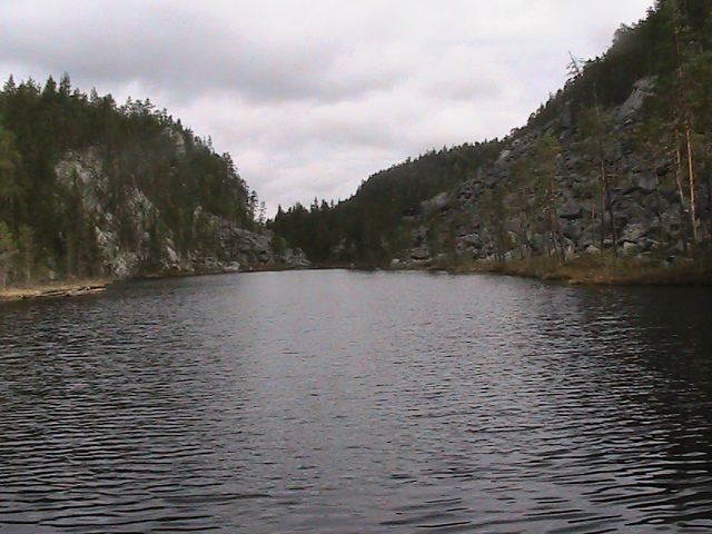
This reservoir is located in the central part of the Republic of Karelia, and has a tectonic origin - the lake was formed as a result of a break in the earth's crust, as clearly evidenced by the symmetry of its shores. The name of the lake is translated as "the longest" - occupying up to 200 meters in width, it extends for 5 kilometers in length. In some places, the depth exceeds 200 meters.
On the northern shore of the reservoir there are parking lots, convenient places for fishing and launching boats. When moving south, the banks become higher, forming a gorge with rocks rising 100 meters above the water. Virgin nature, silence and absence nearby settlements make this place especially attractive for lovers of solitude.
White Sea
This inland sea, located in the north of the European part of Russia, belongs to the Arctic Ocean basin and has an area of 90 square kilometers. Due to the cold water even in summer (up to 20 degrees), there is not too much tourist flow on the White Sea, and nature in many places remains untouched.
On the islands of the sea coast, blueberries and mushrooms grow abundantly, in the water you can see jellyfish, fish, seals and beluga whales. A unique spectacle is the seabed after low tides - it is filled with a variety of living organisms.
Lake Ladoga (Ladoga)
Located in Karelia and Leningrad region and is the largest fresh water reservoir in Europe - the length of the lake is 219, and the greatest width is 138 kilometers. The northern shores are high and rocky, with many bays, peninsulas, large and small islands; the southern coast is shallow, with an abundance of rocky reefs.
Along Ladoga there are a large number of settlements, ports and recreation centers, numerous ships glide along the water surface. Numerous historical finds from different eras have been found at the bottom of the lake, and even now these places are popular among diving enthusiasts. Mirages and brontides also occur here - a rumble coming from the lake, accompanied by the seething of water or weak vibrations of the earth.
Lake Onega (Onego)
This lake is called the younger sister of the great Ladoga - it is the second largest fresh water body in Europe. There are more than 1,500 islands of various sizes on the territory of Onego, dozens of ports and marinas are located on the shores, and the Onego Sailing Regatta is held annually.
The water in the lake is clean and transparent thanks to the mineral shungite, which is literally lined with the bottom. In addition to fish, there is a bivalve mollusk that grows mother-of-pearl balls of pearls in its shell.
Taiga forests rich in mushrooms and berries, the charm of northern nature, a huge number of historical, architectural, and folk art monuments attract many tourists to these places.
Onega petroglyphs
On the eastern coast of Lake Onega in the Pudozh region of Karelia, there are ancient rock paintings dating back to the 4th-3rd millennia BC. They are collected in 24 separate groups and cover an area of 20 kilometers, more than half of the petroglyphs are located on the capes Peri Nos, Besov Nos and Kladovets.
In total, about 1100 images and signs are carved into the rocks, mainly drawings of birds (especially swans), forest animals, people and boats. Some petroglyphs are up to 4 meters in size.
Among the mystical figures is the mysterious triad "demon, catfish (burbot) and otter (lizard)." In order to neutralize this evil spirits, around the 15th century, the monks of the Murom Holy Assumption Monastery knocked out a Christian cross over the image.
Kinerma village
The name of this ancient Karelian village, lost in the Pryazha region, is translated as "precious land". The settlement, founded over 400 years ago, has up to two dozen houses, half of which are architectural monuments. The buildings are located in a circle, in the center of which is the chapel of the Smolensk Mother of God and the old cemetery.
More recently, the fate of the village was in question, only 1 person lived here permanently. However, thanks to the efforts of local residents, it was possible to restore buildings, improve life, and attract tourists. For the preservation of the historical appearance of Kinerma, it was recognized as a complex monument of the wooden folk architecture of the Karelian Livviks. She also won the competition "The most beautiful village in Russia."
Museum-Reserve "Kizhi"
The main part of this unique open-air museum is located on Kizhi Island in Lake Onega. The heart of the collection is the ensemble "Kizhi Pogost", consisting of the 22-domed wooden Church of the Transfiguration, the smaller Church of the Intercession and the bell tower uniting them, now the complex is included in the UNESCO World Heritage List.
The museum is constantly replenished with chapels, houses, icons, household items, outbuildings brought from the surrounding Karelian, Russian and Vepsian villages, it also presents a number of historical objects of Zaonezhie and Petrozavodsk.
Thanks to its height of 42 meters, it has become the tallest wooden church in Karelia. The interior decoration has survived to this day and, with its modesty, contrasts with rich modern temples.
A visit to the Assumption Church is not included in the list of mandatory routes, there is no invasion of tourists, but the newlyweds get married and the locals baptize their children. It is worth coming here for the sake of the surrounding beauty and the special atmosphere of this place.
G. Pakin: [email protected]
No synthetic blende can replace the living breathing stone of a natural rock.
Grandfather Shchukar.
Karelian routes can be made more interesting and varied. if you include visits to natural climbing walls and training there with the development of mining equipment. Below are the walls that seemed interesting to the author:
1. Impilahti rocks. Northern Ladoga.
2. Kollasjoki river canyon.
3. Mount Lysaya (top Kupinas 409.3 m) in the area of st. Peninga.
4. Coastal rocks of the lake. Pisan.
5. Wall of the city of Unut (316 m).
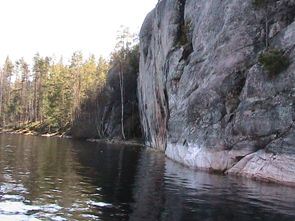
The rocks of Impilahti.
The dirt road departs south from the motorway on the eastern outskirts of the village of Impilahti.
The shore of the Impilahti Bay near the village is swampy and overgrown with reeds. From the highway 4 km along a country road past the beautiful lake Neuvosenjärvi and further along the trail bypassing the town of Pullivuori (87.6 m). A ridge of rocks 40-60 m high approaches the shore of the Impilahti Bay of Lake Ladoga. The rock wall stretches for 1 km and breaks into the water at a negative angle. These are the famous rocks of Impilahti:

They are composed of red granite, up to 60 m high, with a steepness of 70-90 degrees. Overhanging rocks go into the water:

The most difficult routes are laid here, on the wall there are marks 6C + and 7B.

From above, a panorama of the bay opens. Trout farm houses are visible on the right bank:

At the top of Pullivuori (86.7 m) there is a burnt forest. In a clearing under the rocks, a place for overnight stays. True, the place is humid (previously there was a camp for participants in all-Union competitions). Now the rocks are rarely visited.

Along the shore, bypassing the town of Pullivuori, there is a picturesque path to the rocks of Haukkavuori (76.8 m). A wall of gray granite 40 meters high breaks into the water of the bay:


To the south, a black 12-meter wall goes into the water at a negative angle, hanging over the surface of the lake, drops of water fall into the lake 1 m from the shore:
Kollasjoki canyon.

Located 14 km above the mouth of the river. The length is about 1 km, the walls of the canyon are 15-20 m high and have a steepness of 70-90 degrees. There are slopes to the water. There are 3 waterfalls in the canyon, 2-3 m high. The river is popular for rafting during high water, in summer it is shallow.


Fault at the top of Kupinas (409.7 m).
It is located in the Lysaya Gora massif, 6 km west of the station. Peninga.

It is more convenient to climb it along the western slope of Lysaya from the logging road, which goes to (NW) along the slope along the valley of the right tributary of the river. Cabinet. Opposite the top, you can cross the stream along the beaver dam (ford), from here it is 2 km of a gentle ascent through overgrown clearings. The top with a fallen wooden tower is on a vast plateau covered with moss and overgrown with dwarf pines. Close to the edge of the forest. To the east of the summit, a 1.5 km long fault passes from NW to SE, with rock outcrops along the western wall. In the region of the city of Kupinas, the depth of the fault sharply increases to 35-40 m. There is a smooth quartzite rock with a steepness of 60 degrees and a height of 30 m.

There are few cracks, the lugs are smoothed out, the shelves are licked - right out the sole of the el Capitan in California, where most beginners end their route.

Rocks of Lake Pisan.

The approach from the lake Top. Myarat.


Clearing in front of the lake. View of the lake from the spur. 280 m
The road from the village of Gumarino, enveloping the northern tip of the lake. Top. Myarat, deviates to (B) to the foot of the hill, then 3 km goes along it to (C), gradually gaining height. On (W) Karelian views open up from clearings, 30 km on (SW) a dark strip of the town of Vottovara is visible. The road goes to a wide saddle and crosses to the (B) - slope. Before that, a logging road departs at (W). It first goes down, but after 200 m it turns to (C), to the next hill. After 1 km, it descends between rock outcrops to a new clearing running from (S) to (N) along (E) the shore of Pizanets Lake. At the clearing, the logging road is divided into (N)- and (S)-ends. Along it 500 m to (N), then to (W) in the direction of the coastal spur (elev. 280 m) at the (S) edge of the lake. The lake itself is not visible, it lies at the bottom of the fault in a narrow crack at a depth of 100 m. Only from the very edge opens a grandiose view of the lake in the rocks of gray quartzite.


There are several viewing platforms on the spur. They are connected by a path, which then descends to the bottom of the fault between two small lakes (the water from them flows into the Upper Myarat). The lakes are extraordinarily beautiful, framed by rocky walls and coniferous forests. (H)-shore - a rocky wall 50-70 m high, steepness of 70-80 degrees, (B)-shore - large-block scree, turning into destroyed rocks. When you look from above, 10-meter boulders seem like children's cubes. You won't see anything like this in the North. Ladoga, nor in the Kollas Canyon. I recall the flooded canyons of tributaries on the large dammed lakes of the Tien Shan and Pamir. The scale is unusual for Karelia.

The trail crosses the stream at the bottom of the fault and climbs the rocks (З)-walls. They offer equally interesting views.

In the (S)-part of the lake. On the (W)-shore of Pisa there is an interesting rock face with extended overhanging sections and complex cornices. There is a parking lot near the lake under the rocks. Difficult routes for climbers suggest themselves: 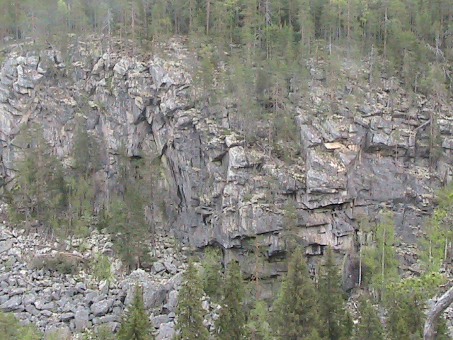
1 km behind the next spur into the lake, 10-meter icing tongues hang from the rocks (B) of the shore. I never thought that on May 25 in Karelia you can still do ice climbing! The stream flowing over the rocks formed these hanging "glaciers" during the winter cold, which will last until mid-summer.

Rock wall of the city of Unut (316 m).

On the western shore of the Unutozero stretches a high wooded rock-scree wall of the city of Unut. An unpleasant swamp stretched under the wall. For some reason, the rocks in Karelia like to break off in quicksand. It is more convenient to climb Mt. Unut from the logging road leading from Maslozero. A dirt road stretches from it along the summit plateau, in some places coinciding with the sight.

If you climb from the side of Unutozero, in order to cross the swamps of the southern part in a narrow place, you need to move along the lake along the (W) - shore to a large island, go around it to the right. Here, from the shore of a small bay, start climbing. The shore is large stones, then a swampy forest immediately begins. It gently rises to the foot of the wall, giving way to open areas of moss swamp. The wall is a large-block scree with a steepness of 60 degrees, with outcrops of destroyed rocks.

Quartzite boulders are covered with moss, small pines in the ravines. The elevation difference is 150 m, the steepness of the rock wall is up to 60 degrees. Not bad for Karelia. More like the slopes of the mountains of the Central Sayan.

On the wide sloping ledges, you can quickly climb to a wide wooded plateau, at its edge there is a beautiful view of the lake. On the hills - "Hiisi gardens" - placers of large boulders.

The main peak is hidden in the forest, a long gentle ascent leads to it. On the wooded plateau there are boulders, the remains of a wooden tower.
There are other walls as well. For example, a rock mass elev. 76.8 m in the middle reaches of the river. Northern (Belomorskaya) Shuya, 30-meter "lamb foreheads" on the right bank of the Kums River near Medvezhyegorsk:

Canyon Kiviristi on the river. Okhta, coastal cliffs on the river. Chirka-Kem at the rapids of Krivoy and Takhko:

Rocky cliffs up to 35 m high on the western side are on the islands of Filin and Bol. Petik on the Knyazhegubsky reservoir is already in the Murmansk region and many others.

The quarries of Ruskeala and the Northern Ladoga region in the area of the city of Pitkyaranta are not considered here, the rocks near the station. Shueretskaya and on Lake Onega near Medvezhyegorsk, about which there is a lot of information in other sources.
Shuisky rocks are located near Shuiskaya station, about 20 km. from the city. It is convenient to get here by train, bus or car. From the station to the rocks about 40 - 50 minutes walk. First, from the fork in the highway near the railway station, to the left along the asphalt road to the gas pipeline, then along the country road that goes along the pipe to the left to the distribution point, from here the path marked with blue paint goes to the right into the forest. Convenient parking under the rocks. The rocks have been used for training tourists, speleologists, rescuers and rock climbers for many years, and are an excellent training ground for practicing rock skills.
The height of the massif in the main part is up to 20 meters, the length of some climbing routes is up to 15 meters. Most of the main massif with the most interesting and difficult climbing routes was cleared relatively recently - in 1994. True, due to the low location (the Shuya rocks are a break in the earth's surface) and the huge amount of moss and lichens on the rocks, constant cleaning of the rocks is required.
The massif is characterized by a strongly dissected, destroyed relief, with a large number of overhangs, cornices and positive mirrors, which are of great interest to climbers of any level of training.
Historically, the local rocks were mastered by the Karelian public for a long time. Sport climbing history began relatively recently, in the early 90s. It was then that our representatives began to systematically make trips to such climbing centers as the Crimea, Moscow, St. Petersburg. Acquaintance with the basic principles of this sport took place there. There, in communication with the best representatives of the climbing world, an understanding of the aesthetics, psychology and tactics of rock climbing as an independent sport was laid, which was very different from the views that prevailed in the tourist environment.
Then, based on the experience of passing numerous, classic climbing routes of various categories of difficulty in such a climbing mecca as the Crimea, they were cleaned of live stones and moss, the first climbing routes on the Shuisky rocks were developed and passed, set in accordance with the norms and categories adopted in rock climbing.
Since then, rock climbing in Karelia, and Shuisky rocks, as the main training place for Petrozavodsk rock climbers, has gone through different times. The number of rock threads is constantly increasing, their complexity is growing, and the development of new types of climbing in the world; Drytooling - rocky routes, passed in winter conditions with the help of ice tools, did not pass by our city.
Since 2000, many climbing routes have been climbed on our rocks in this promising technique, which violated the canons and greatly pushed the limits and limitations. With the help of this technique, the scale of difficulty of climbing and ice climbing routes in large mountains has greatly increased. And the aesthetics, value and sportiness of this type of climbing puts it on a par with classic rock climbing and bouldering, which has become very popular recently.
Array of Shuisky rocks- for the convenience of orientation and description, it is divided into several sectors, divided on the ground by couloirs and pronounced landmarks. The total length of the array is about 150 meters.
Sector "A" - the leftmost part of the array when viewed from below. In the leftmost part, the rocks are heavily destroyed, covered with moss and grass, their height gradually disappears. From sector B, on the right, is separated by a depression and a fault heavily overgrown with moss, along which a large number of winter routes pass, and at present the simple climbing route "Cherchet la femme". Sector A in the main part has a very interesting relief with a slight overhang along the lower tier and a cornice in the upper part. Height up to 18 meters. The ceiling cornice on the right side is an excellent reference point. The characteristic mirror under it is characterized by technical and accurate climbing in winter conditions, and even in summer it pulls into the category. This area of rocks, overgrown with moss, has not yet been cleaned, it is still possible to pass a large number of new difficult drytooling routes in winter, and after serious cleaning, climbing routes in summer.
Sector "B» - the central and currently most developed part of the rocks. On the left it borders on sector A, on the right it is separated from sector C by a deep couloir along which a simple winter route passes, and beginners sometimes learn to climb in summer. This is the highest part of the Shuya rocks. The first technical routes were climbed here, after a thorough cleaning of moss and poorly lying stones, back in 1994, unfortunately, since then they have been thoroughly overgrown, but still allow for targeted climbing training.
Sector "C" - a magnificent section of rocks, characterized by a pronounced huge cornice, located along the entire length of the sector. On the left and on the right, it is highlighted by deep couloirs, the lower part, in some places simple and positive, in some places overhanging, and difficult. The cornice in the middle is amazing. There is an old bolt path, made for training climbers and speleologists. All the routes currently passed along the cornice are tied to cracks and faults, the passage of the cornice along the surface is possible, but still waiting for its pioneers, such options will pull on the highest climbing categories. This section of the rocks is the most difficult and has great climbing prospects, subject to the growth of the skills of future athletes.
Sector "D» - the rightmost part of the Shuisky rocks, on the left a couloir with several trees, on the right side the main path goes up the rocks. The positive relief with various cracks is simple, but from left to right the solidity of the rocks increases, a cornice appears from below and routes in the right part of the sector are of interest even now. Once it was the main site for climbing and competitions, recently, with the increase in the general level of skill of climbers, it is almost not used, and is gradually overgrown with moss.
Everything to the right, separated from "Sector C" by a large internal angle with growing trees, was once of great interest. Positive monolithic rock forehead with a small cornice in the lower part, dissected by numerous cracks. The simple "Bicycle" route used to be popular. In winter, this section of the rocks is covered with snow, in some years with firn, now it is often walked using the dry tooling technique. In summer, all the interest for rock climbing in modern conditions is concentrated in sectors A, B, C. The first ascents of the main rock routes were made in the 90s. . Difficulty assessment was made on the basis of a large number of difficult classical routes passed in the Crimea and partly in Karelia on the rocks of Hiytola and Yastrebinoye Lake.

The left part of the Shuisky rocks - sector " A»
| № | Name | K/s | Year | Description | author | Pioneer | Year |
| 1. | 6C | 2010 | Scallop start to a large hollow under the overhang, straight up under the mirror, pass on the left. | Minin Stas | Savchuk Kirill | 2010 | |
| 2. | 6B+ | 2010 | Up slightly to the left, the gaps are limited on the left and right, the overhanging forehead goes to the right through the hollow, the mirror is to the left. | Minin Stas | Savchuk Kirill | 2010 | |
| 3. | (no limit) | 6A+ | 2006 | There are no restrictions, cracks and cracks are open, the mirror passes on the right side. | Balagurov Igor | Balagurov Igor | 2006 |
| 4. | (with limited) | 6A | 2008 | A positive smooth wall, rigid restrictions, at the start there is a large hollow, in the middle part there are two large shelves on the left and right, in the upper part the cornice goes straight up. | Bykov Alexey | Bykov Alexey | 2008 |

The central part is the sector " B»
| № | Name | K/s | Year | Description | author | Pioneer | Year |
| 1. | (with limited) | 6A+ | 2010 | Straight up under the overhang, where it connects to the No. 2 min. Then it bypasses the edge on the left and goes to the left under the protruding edge of the edge with the restriction of the positive part of the rock, the base of the edge. | Minin Stas | Minin Stas | 2010 |
| 2. | (with limited) | 6A+ | 1994 | Start along the overhang traverse to the left, under a characteristic rib, along it a couple of meters up and traverse to the right under the cornice, which is passed on the left. Up - keep 2 meters from the edge of the rock. | Wozniuk | Wozniuk | 1994 |
| 3. | 7A+ | 2007 | Start with “Keep your ass”, but immediately straight up the minuses, to the first key, then under the eaves, which goes straight along the edge to the top part. | Minin Stas | Korablev Sergey | 2007 | |
| 4. | 7B? | Beginning a little to the right of motorway No. 3, the middle in its own way, the cornice is strictly in the middle, and further along the edge | Minin Stas | ||||
| 5. | 7A | 1997 | A very beautiful technical start further up to the overhang is simple. The cornice is simple, but it takes some thought. The top is simple and positive. | Minin Stas | Minin Stas | 1997 | |
| 6. | Most the best route | 7A+ | 2010 | Completely its course on the minuses below, a smooth forehead in the middle part and a positive section above. | Minin Stas | Garder Alexander | 2010 |
| 7. | 6A+ | 2002 | The "Parallel cracks" option is more complex without using the right slot. Start with the constraint, without using the ledge of the shelf on the right. | Minin Stas | Minin Stas | 2002 | |
| 8. | 6A | 1994 | Strict restriction at the start, simple rocks on the right are limited, the key is in the center, the top is positive. | Wozniuk | Wozniuk | 1994 | |
| 9. | Right crack | 6A+ | 2011 | The “Parallel Cracks” option is more complex without using the left gap and large blotches between the cracks. Start with the constraint, without using the ledge of the shelf on the right. | Minin | Minin | 2011 |
| 10. | Shorty | 6A | 1997 | The shortest one is here, starting along an overgrown shelf, then a very complex movement in dynamics from a hollow. | Minin Stas | Minin Stas | 1997 |
| № | Name | K/s | Year | Description | author | Pioneer | Year |
| 1. | (with limited) | 6A | 2002 | Restriction, at the bottom you can not use the shelf exit from under the cornice on the right through the fault, then straight up through the overhang, without going to the sides. | Minin Stas | Minin Stas | 2002 |
| 2. | (with limited) | 6B+ | 2010 | The limit is a crack forming a cornice, everything is open on the right, above the cornice strictly along the right slab. | Minin Stas | Minin Stas | 2010 |
| 3. | large cornice | 7C? | 2008 | It passes exactly in the middle of the main overhang of a large cornice with access to the cornice at a pronounced rib, and straight up along it. | Minin Stas | Korablev Sergey | 2008 |
| 4. | 6A | 1994 | A very simple ruined beginning, in the middle, a passage to the left of the fault of mint No. 5. top positive | Wozniuk | Wozniuk | 1994 | |
| 5. | 5 B | 1994 | Down loose large blocks, then a key with access to a pronounced overhanging stone, you can use the gap above. | Wozniuk | Wozniuk | 1994 | |
| 6. | 6A | 1994 | The beginning is 2 meters to the right of the “Hooks of the Left” up the overhang with the exit with the original intense movement to the landmark - the stone on the right. The slot above is fully open. | Wozniuk | Wozniuk | 1994 | |
| 7. | (with limited) | 6B+ | 2008 | To the exit to the cornice it goes the same way as m-t No. 6. Then the exit from under the overhang. Further, along the surface of the wall, leaving a pronounced gap on the left. Top through a simple cornice. | Minin Stas | Korablev Sergey | 2008 |
| 8. | 7B? | 1997 | A large cornice is dissected by a smooth inner corner and covered with 2 cornices from above, the exit to the cornice into the corner is difficult. | Minin Stas | Bykov Alexey | 2010 | |
| 9. | fontainebleau | 6B+ | 1994 | A very interesting long traverse above the ground itself, starting from mint No. 8 to the end of the cliffs of the sector and back, the key is the cornice, it is important to return to the starting point. | Wozniuk | Wozniuk | 1994 |
| 10. | Nose (limited) | 7 | Start on the overhang in the form of a nose, then along the gap through the eaves. |
Sector D - the rightmost part of the Shuisky rocks
| № | Name | K/s | Year | Description | author | Pioneer | Year |
| 1. | A bike | 5A | 80s | Passes along the faults from left to right, very simply positive. | 80s | ||
| 2. | First move | 6A | 80s | Passes along the smooth wall next to the "Bicycle" rift, which is limited. | 80s | ||
| 3. | Second move | 1994 | Passes along a smooth wall along the second crack from the "Bicycle" | 1994 | |||
| 4. | Third move | Passes along a smooth wall along the third, from the "Bicycle" an implicitly expressed crack | |||||
| 5. | Fourth move | Cornice at the start, then along an implicit gap and top strictly between two gaps without using them. | |||||
| 6. | Festival 2010 | 2010 | It was cleaned for the extreme festival in 2010, for drytooling. | Bykov Alexey | Bykov Alexey | 2010 |
Mixed - Dry tooling
Rock routes traversed with ice tools and crampons. This technique was used for a long time by climbers exclusively as a specialized preparation for winter and high-altitude technical ascents. Winter, severe cold, ice, snow, which covered all the holds and shelves of rocks, a kind of climbing found few fans.
There has been a dramatic rise in ice climbing standards over the last few years; most of the icefalls were cleared, and the difficulty scale rose rapidly. This was also due to the fact that many previously impassable cliffs were climbed using ice axes and crampons, allowing the passage of several disparate sections of ice to be combined. This method is known as dry tooling, and accordingly led to the appearance new system categories of difficulty. Due to the lack of information on the classification of routes and the insufficient set of reference routes in the iconic areas of drytooling. It is not possible to classify these routes in numbers. Therefore, we present here the ranking of the tracks passed so far in our own feelings. Based on the system adopted in Soviet mountaineering. Evaluation of the complexity of free climbing is carried out according to gradations: I - very easy; II - lung; III - average; IV - difficult; V - very difficult; VI - extremely difficult. Each gradation has steps: lower (-) and upper (+).
On all schemes, the routes covered in different techniques and conditions are highlighted in their own color. Red runs- rock-climbing routes, climbed for the first time, in the technique characteristic of sports overcoming rocks. (highlighted in red) yellow trails - Mixed - Dry tooling; drytooling routes climbed for the first time in winter, in harsh conditions, and with the use of climbing equipment; (highlighted in yellow).
| № | Name | K/s | Description |
| 1. |
4 ks - difficult |
4 |
It is clearly divided into 4 parts, very physically intense, from the power at the beginning to the technical minuscule on the smooth mirror at the top. |
| 2. |
3+ ks - medium |
3+ |
At the bottom, a restriction on the right, a slot related to m-t 3, in this case a very technical beginning and end on a mirror. From a small overhang down the moss to a ledge from here to the right upwards a technical area and unpleasant picking at the top. |
| 8. | 2+ ks - easy | 2+ | Winter version of the route "Cherchet la femme". |
| 9. | 2+ ks - easy | 2+ | A short forceful overhang at the bottom, then strictly along a pronounced angle, the cornice strictly upwards without going to the shelf on the right. |
| 10 | 4 ks - difficult | 4 | Climbing 6a+ "Keep your ass" with independent start. Above the upper cornice, do not go to the left on the shelf. |
| 11 | 3 ks - average | 3 | Winter version of the route "Parallel cracks". |
| 12 | 1 ks - very light | 1 | A simple short couloir, traversed in the climbing technique of spreading. |
| 13 | 3 ks - average | 5+ | Winter version of the "happy end" route. |
| 14 | |||
| 20 |
3 ks - average |
3 | |
| 21 |
2 - ks - light |
2 | Competitive track - Extreme Sports Festival 2010 |
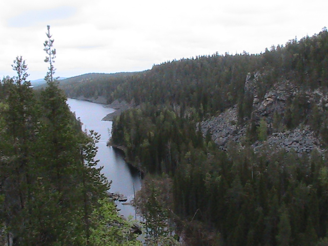
The surroundings of the village of Impilahti are very beautiful, especially the rocks along the shores of the bay. Impilahti Rock is a famous rock mass among rock climbers and hikers. It is located near the village of the same name on the shores of the bay of Lake Ladoga.
The Impilahti rocks are a great place for rock climbing.
The road to the rock starts in the village of Impilahti. It is 3-4 km along the left bank of the bay. The approach to the rocks begins along several houses, then along a well-trodden path, past a small lake. The whole journey will take no more than an hour.
The rocks of Impilahti- a rock massif very famous among the climbing and tourist community in Karelia near the village of Impilahti, located 180 km. from Petrozavodsk. On the shores of the magnificent bay of Lake Ladoga, as long as a river, and rather reminiscent of the Norwegian fjords. A low shore of the bay covered with fields and forests on one side, and on the opposite side a high shore overgrown with pine forests, with numerous rocky foreheads smoothly and slopingly descending into the water of the lake.
Of interest to climbers is a rocky massif formed a long time ago, a high bank in one place seems to be sawn down and a fifty-meter vertical line of red and gray granite that appeared here, with cornices, overhangs, smooth mirrors, dissected by numerous cracks, made this area their favorite for many place. This is truly one of the best places for outdoor activities and sports.
The rocks on the main massif in the left part are pierced with bolts, they allow comfortable climbing with a lower rope, their height is about 20 meters. Unfortunately, many routes and interesting options have not been broken, and many of the broken ones have old bolts and are also extremely rare, especially in the lower part. Here, despite the small height, compared to the right side, the main part of the sports routes is concentrated.
Nearby on the right is a simpler, but higher massif, about 50m high. There are no difficult categorical routes here, but for beginners, these rocks are of great interest for their length and the ability to really feel the height. The rocks are widely known. Previously, various training camps and competitions were often held here, up to the Russian championships in rock climbing among juniors and in tourist all-around. Recently, interest in the area has declined significantly, the paths are overgrown with grass in the middle of summer, and it turns out to be a wonderful secluded place for relaxation and calm climbing. The level of the rocks is quite high due to their diversity. In addition, a large number of routes and opportunities that have not yet been passed are hidden in the relief.
Unfortunately, there are no routes of super high categories here, but even an experienced climber will find opportunities to improve and diversify his skills here.
Perhaps this is the best place for climbing in Karelia, both in summer and autumn.
Approximately 1 kilometer from the rocks of the main massif in the neighboring bay of Lake Ladoga - Petrovsky, there is also a rocky massif. This is a rocky bastion that breaks right into the water. In the mid 90s. years they were partially cleaned and broken through to the championship of Russia among juniors on natural terrain. Unfortunately they are currently abandoned and in need of cleaning and preparation. Breaking straight into the water, they are of particular interest for climbing, the potential of the array is up to 15 routes up to 7 categories of difficulty. Accommodation is possible very close to the rocks, for climbing some routes you need a boat or a raft.
You can live in charming parking lots on the coast, the places here are even more secluded and quiet. The region of the Impilahti rocks is a place of indescribable beauty, at any time of the year. It is impossible to forget the local places, having come here once, you want to come back here again and again.
Directly under the rocks there is a scattering of huge boulders, a little further a meadow overgrown with grass, and sloping stone ridges on which there are many convenient places for parking and tents.
Pine forest, thickets of reeds in the warm bay of the lake, a flowering field, yellow at the beginning of summer from a huge number of flowers, and at the height of the season, covered with tall thickets, there are incredibly beautiful places in Karelia and one of them is the Impilahti rocks. Huge opportunities for recreation and sports, and anyone will find peace and joy here.
The article uses information and photos from open sources.
tourism.karelia.ru
It's time to turn the final page of our summer menu:
Departure to the former Finnish territories WITHOUT VISAS AND PASSPORTS (290 km). First stop - Marble Park Ruskeala. This picturesque monument of nature and mining.
Since Catherine's time, first-class Russian marble has been mined here. Today it is the most beautiful place in Karelia. Artificial white marble rocks picturesquely hang over the emerald water surface of a small lake, grottoes beckon with their mystery.
In the mountain park "Ruskeala" we offer a choice of:
Option 1.
Option 2. Underground route "In the cave of the mountain king..." (1300 rubles, 6-17 years old 700 rubles).
Option 3.
Departure on the way back.
way cinematic stop. The famous "perch threshold" - Ahvenkoski waterfall. Locals sometimes call it "Zhenka River". Once upon a time, a bathing scene of one of the heroines of the film “The Dawns Here Are Quiet” was filmed here.
Old the city of Serdobol (Sortavala).
Lunch, complex in a cafe in Sortavala (350 rubles). Free time. Optional:
16:00. Excursion to the island of Valaam
Tour duration: 5 hours. The time spent on the island of Valaam is 2.5 hours.
Water trip on a meteor to the island on Lake Ladoga 45 min. As if the fabulous backs of whales or old giant fish rise from the water of Ladoga skerries - fjords.
shrines of the temple: the relics of the founders of the monastery Herman and Sergius of Valaam.
return to worldly vanity, to the mainland.
16.00.
Churches of Nicholas the Wonderworker, built at the expense of St. Petersburg merchants Eliseevs in the Russian style according to the project of arch. N. P. Comb. Rise to Mount Kuhavuori
21:00.
www.kandagar.com
G. Pakin: [email protected]
No synthetic blende can replace the living breathing stone of a natural rock.
.
nbsp; Grandfather Shchukar.
Karelian routes can be made more interesting and varied. if you include visits to natural climbing walls and training there with the development of mining equipment. Below are the walls that seemed interesting to the author:
1. Impilahti rocks. Northern Ladoga.
2. Kollasjoki river canyon.
3. Mount Lysaya (top Kupinas 409.3 m) in the area of st. Peninga.
4. Coastal rocks of the lake. Pisan.
5. Wall of the city of Unut (316 m).
The rocks of Impilahti.
The dirt road departs south from the motorway on the eastern outskirts of the village of Impilahti.
The shore of the Impilahti Bay near the village is swampy and overgrown with reeds. From the highway 4 km along a country road past the beautiful lake Neuvosenjärvi and further along the trail bypassing the town of Pullivuori (87.6 m). A ridge of rocks 40-60 m high approaches the shore of the Impilahti Bay of Lake Ladoga. The rock wall stretches for 1 km and breaks into the water at a negative angle. These are the famous rocks of Impilahti:

They are composed of red granite, up to 60 m high, with a steepness of 70-90 degrees. Overhanging rocks go into the water:

The most difficult routes are laid here, on the wall there are marks 6C + and 7B.

From above, a panorama of the bay opens. Trout farm houses are visible on the right bank:

At the top of Pullivuori (86.7 m) there is a burnt forest. In a clearing under the rocks, a place for overnight stays. True, the place is humid (previously there was a camp for participants in all-Union competitions). Now the rocks are rarely visited.

Along the shore, bypassing the town of Pullivuori, there is a picturesque path to the rocks of Haukkavuori (76.8 m). A wall of gray granite 40 meters high breaks into the water of the bay:


To the south, a black 12-meter wall goes into the water at a negative angle, hanging over the surface of the lake, drops of water fall into the lake 1 m from the shore:

Kollasjoki canyon.

Located 14 km above the mouth of the river. The length is about 1 km, the walls of the canyon are 15-20 m high and have a steepness of 70-90 degrees. There are slopes to the water. There are 3 waterfalls in the canyon, 2-3 m high. The river is popular for rafting during high water, in summer it is shallow.


Fault at the top of Kupinas (409.7 m).
It is located in the Lysaya Gora massif, 6 km west of the station. Peninga.

It is more convenient to climb it along the western slope of Lysaya from the logging road, which goes to (NW) along the slope along the valley of the right tributary of the river. Cabinet. Opposite the top, you can cross the stream along the beaver dam (ford), from here it is 2 km of a gentle ascent through overgrown clearings. The top with a fallen wooden tower is on a vast plateau covered with moss and overgrown with dwarf pines. Close to the edge of the forest. To the east of the summit, a 1.5 km long fault passes from NW to SE, with rock outcrops along the western wall. In the region of the city of Kupinas, the depth of the fault sharply increases to 35-40 m. There is a smooth quartzite rock with a steepness of 60 degrees and a height of 30 m.

There are few cracks, the lugs are smoothed out, the shelves are licked - right out the sole of el Capitan in California, where most beginners end their route.

Rocks of Lake Pisan.

The approach from the lake Top. Myarat.


Clearing in front of the lake. View of the lake from the spur. 280 m
The road from the village of Gumarino, enveloping the northern tip of the lake. Top. Myarat, deviates to (B) to the foot of the hill, then 3 km goes along it to (C), gradually gaining height. On (W) Karelian views open up from clearings, 30 km on (SW) a dark strip of the town of Vottovara is visible. The road goes to a wide saddle and crosses to the (B) - slope. Before that, a logging road departs at (W). It first goes down, but after 200 m it turns to (C), to the next hill. After 1 km, it descends between rock outcrops to a new clearing running from (S) to (N) along (E) the shore of Pizanets Lake. At the clearing, the logging road is divided into (N)- and (S)-ends. Along it 500 m to (N), then to (W) in the direction of the coastal spur (elev. 280 m) at the (S) edge of the lake. The lake itself is not visible, it lies at the bottom of the fault in a narrow gap at a depth of 100 m. Only from the very edge opens a grandiose view of the lake in the rocks of gray quartzite.


There are several viewing platforms on the spur. They are connected by a path, which then descends to the bottom of the fault between two small lakes (the water from them flows into the Upper Myarat). The lakes are extraordinarily beautiful, framed by rocky walls and coniferous forests. (B)-shore - a rocky wall 50-70 m high, steepness of 70-80 degrees, (B)-shore - large-block scree, turning into destroyed rocks. When you look from above, 10-meter boulders seem like children's cubes. You won't see anything like this in the North. Ladoga, nor in the Kollas Canyon. I recall the flooded canyons of tributaries on the large dammed lakes of the Tien Shan and Pamir. The scale is unusual for Karelia.


The trail crosses the stream at the bottom of the fault and climbs the rocks (З)-walls. They offer equally interesting views.


In the (S)-part of the lake. On the (W)-shore of Pisa there is an interesting rock face with extended overhanging sections and complex cornices. There is a parking lot near the lake under the rocks. Difficult routes for climbers suggest themselves:

1 km behind the next spur into the lake, 10-meter icing tongues hang from the rocks (B) of the shore. I never thought that on May 25 in Karelia you can still do ice climbing! A stream flowing over the rocks formed these hanging "glaciers" during the winter cold, which will last until mid-summer.

Rock wall of the city of Unut (316 m).

On the western shore of the Unutozero stretches a high wooded rock-scree wall of the city of Unut. An unpleasant swamp stretched under the wall. For some reason, the rocks in Karelia like to break off in quicksand. It is more convenient to climb Mt. Unut from the logging road leading from Maslozero. A dirt road stretches from it along the summit plateau, in some places coinciding with the sight.

If you climb from the side of Unutozero, in order to cross the swamps of the southern part in a narrow place, you need to move along the lake along the (W) - shore to a large island, go around it to the right. Here, from the shore of a small bay, start climbing. The shore is large stones, then a swampy forest immediately begins. It gently rises to the foot of the wall, giving way to open areas of moss swamp. The wall is a large-block scree with a steepness of 60 degrees, with outcrops of destroyed rocks.

Quartzite boulders are covered with moss, small pines in the ravines. The elevation difference is 150 m, the steepness of the rock wall is up to 60 degrees. Not bad for Karelia. More like the slopes of the mountains of the Central Sayan.

On the wide sloping ledges, you can quickly climb to a wide wooded plateau, at its edge there is a beautiful view of the lake. On the hills - "Hiisi gardens" - placers of large boulders.

The main peak is hidden in the forest, a long gentle ascent leads to it. On the wooded plateau there are boulders, the remains of a wooden tower.
There are other walls as well. For example, a rock mass elev. 76.8 m in the middle reaches of the river. Northern (Belomorskaya) Shuya, 30-meter "ram's foreheads" on the right bank of the Kums River near Medvezhyegorsk:

Canyon Kiviristi on the river. Okhta, coastal cliffs on the river. Chirka-Kem at the rapids of Krivoy and Takhko:

Rocky cliffs up to 35 m high on the western side are on the islands of Filin and Bol. Petik on the Knyazhegubsky reservoir is already in the Murmansk region and many others.

The quarries of Ruskeala and the Northern Ladoga region in the area of the city of Pitkyaranta are not considered here, the rocks near the station. Shueretskaya and on Lake Onega near Medvezhyegorsk, about which there is a lot of information in other sources.
www.gpsigma.ru
MASTER CLASSES IN PAINTING IN EXTREME CONDITIONS!
Only with us from the Art Studio "MilArt" -
PASTEL PLAN-AIR IN KARELIA!
Expand text…
Under the guidance of an experienced teacher, climbing artist Mila, you will attend an unforgettable painting master class right on the rocks of Karelia, where:
Learn some basics of color theory,
Get to know the technique of pastel painting,
learn an unusual way of mixing colors,
remember the basics of chiaroscuro and much more.
At the end of the master class, everyone will leave with an unforgettable work (or maybe two), which will remain for you as a pleasant memory of a wonderful trip.
If you love hiking and have long dreamed of learning how to draw from nature - this master class is for you - DON'T MISS A GREAT OPPORTUNITY!
Dates: 12, 13 August
Time: determined on the spot according to the weather, most likely morning or evening, the lesson lasts 2 hours
Meeting point: oz. Yastrebinoye, parking of the alpclub "Shturm"
Cost: 1000 rubles*
*All materials are provided: pastel crayons, pastel paper, nags, wet wipes, tablets.
To have with you - a seat and a good mood.)
How to get there:
By car: to the village of Kulikovo, the car is left in the fields
By train: to st. Blacksmith and then 2 options:
1. Ho Chi Minh Trail
2. By taxi to the fields through the village of Kulikovo
Registration for the lesson by phone. 903-963-2.
vk.com
Tour duration: 9 days / 8 nights (2 overnight trips).
Tour price: from26 550 rubles.
The cost of the tour depends on the chosen category of the hotel room in Karelia. In Rostov-on-Don accommodation in 2-3 bed rooms with private facilities.
Tour program:
1 day. 07/15/18. 05.00. Gathering of the group Sevastopol, pl. Ushakov, exit. Transit across the Crimea. Transit to Rostov-on-Don. Hotel accommodation. Overnight stay.
Day 2 07/16/18.Breakfast. Transit to Karelia in Kondopoga. Night move.
Day 3 07/17/18. Transit . On the way, we admire the magnificent natural landscapes from the window! Arrival at Republic of KareliaAccommodation inhotel "Karelia". Lunch at the hotel, buffet.
12:00. Excursion "The cultural capital of Karelia - the city of Kondopoga".
Today in our summer menu: "Hello, Karelia, let's get acquainted!" Musical carillons.We will get to know the city on foot."Konda" - "pine" - "poga" - "corner" can be proud of not only the best "ship" pines in Russia, but also architectural masterpieces of glass and stone. ice palace has no equal in the Northwest. Two Carillons with their melodic bells they slowly count the city time. Today they will perform familiar melodies especially for you. Palace of Arts- a stone miracle of granite and marble. His pride is two organs: a large German one, and a small French one. Do you want to hear the "main king" of Kondopoga? Organ concert at the Palace of Arts (400 rubles, 300 rubles for children aged 6-14). Waiting for you concert large German organ. A world of sound harmony will open before you: sublimely strict in German, romantic in French, colorful in Italian. "Karelian mountain". National Master Class: we will plunge into the world of traditional culture of the northern people and get acquainted with the peculiarities of the region. Gently touch the strings of an old kantele. They will sing to us about the wind and home. It will always be happy and joyful. To the sounds of a cheerful song, we will learn to dance Karelian, Finnish, Vepsian dances. The guests dance and play the kantele, and the “sorceress Sampo” grinds mountains of rye flour. We will sit together at a wide table and, under the guidance of an experienced master, we will prepare the famous rupittetya (gates). While the pies in the oven are blushing, we will make the amulet-doll "Wisher". Now you will have your souvenir-talisman as a memory of Karelia.
Dessert of the day: tea drinking with fragrant wickets."Plague Gatherings". In the evening we gather around the fire on reindeer skins in the present Sami plague. Together with wise shaman we will get the sacred fire, we will call the spirits of fire, wind and forest with a tambourine, we will conjure! Let's burn the troubles in the fire, scatter the ashes of sadness in the wind! Return to the hotel.
Day 4 07/18/18. Breakfast buffet.
Option 1.
In good weather. Excursion to the famous island of Kizhi. (3,400 rubles, children 5-12 years old 1,800 rubles; the price includes: water transfer to the Kizhi island, entrance fee to the Kizhi island, excursion service along the route). Duration of the tour: 6.5 hours. Time spent on Kizhi Island 2.5 hours. Journey to the monument of the World Cultural and natural heritage UNESCO. A 1-hour 30-minute water trip will begin along the boundless expanse of the open Onego from the city of Kondopoga on covered taxi boats, and will end among numerous islands called Kizhi skerries. We learn about all the secrets of the island when examining the ensemble Kizhi Pogost, let's get acquainted with one of the oldest wooden churches in Russia - Church of the Resurrection of Lazarus, according to rumors, with the ability to heal all ailments and visit the estate Zaonezhsky peasant. Until now, the names of the brilliant masters who created truly the eighth wonder of the world - the temple complex, built without a single nail, remain a mystery.
Option 2.
In bad weather (waves over 1.5 m). Excursion to the island of Kizhi from Petrozavodsk (for an additional fee of 4,500 rubles). Return to the hotel. Lunch, buffet (for an additional fee of 350 rubles). 14.00. Departure for new experiences and natural mysteries Excursion "Welcome to Girvas". A unique geological object, the oldest volcanic crater in Karelia, it is about 2 billion years old!!! Your eyes will see a view of a section of more than 20 lava flows up to 32 m thick and petrified volcanic "bombs", including gas voids. Mighty old giant waterfall Kivach! famous poet and Gavrila Derzhavin talentedly sang one of the brightest sights of Karelia. "A diamond is pouring down a mountain from the heights of four rocks ...". It's time to find out ancient Karelian legend about the emergence of the largest Eastern European waterfalland get to know the national reserve, museum of nature and arboretum. Also see the famous Karelian birch. This is a mystery tree with amazing marble pattern wood. Even in the 21st century, there are disputes among scientists about its origin. Return to the hotel. Dinner, buffet (for an additional fee of 300 rubles). Overnight stay.
Day 5 07/19/18. Breakfast. Excursions to choose from:
— Excursion to the legendary Solovki (4,200 rubles, children 6-10 years old 3,700 rubles).Duration: 19 hours. The time spent on the island of Solovki is 4.5 hours. A 390 km long journey awaits you to the port of Rabocheostrovsk. And further: “Give the mooring lines!” We are going on a sea voyage. We keep the camera ready - it is possible to meet with a ringed seal or a bearded seal, and from the end of June with a beluga whale. Welcome to the famous Solovki island - a unique architectural monument and a place of pilgrimage for believers from all over the world. Acquaintance with monuments Complex of the Solovetsky Monastery.
We will walk around the entire complex of the monastery, visit the existing temples, see the monuments included in the UNESCO World Heritage List, objects of economic activity and the Solovetsky Fortress. Learn about the life of the monks.
Impressions will complement: Excursion "Monastic prison", whose walls hold secrets.
Free time on the island. Lunch in the refectory, complex (for an additional fee of 350 rubles).
In memory of the salty taste of the Solovetsky wind, you can buy the famous White Sea seaweed, as well as cosmetics from kelp, swim in the White Sea. We arrive on the mainland and return to Kondopoga by 02:30.
— Excursion "In search of Karelian papyrus" ( 700 rubles).
Tour duration: 3.5 hours.
Acquaintance with the pulp and paper mill JSC "Kondopoga". We go through a safety briefing, put on a helmet, overalls and forward - into the depths of paper creation. In the production workshop we will see the work of a real BOOM MACHINE from the first stage to the exit of the reel to the packaging machine. We will find out what a “wardrobe” is, and how many “dresses” our “fashionista” is used to changing per hour.
Return to the hotel. Lunch, buffet (for an additional fee of 350 rubles).
Leisure time, outdoor recreation . At your service rental:
– 4-seater rowing boats (200 rubles per hour),
— bicycles (100 rubles per hour),
— fishing rods and spinning rods (from 70 rubles) for fishing in the bay of Lake Onega.
Dinner, buffet (for an additional fee of 300 rubles). Overnight stay.
Day 6 07/20/18. Breakfast. Excursion "Sovereign's road".
We leave along the path of Peter the Great to the first Russian resort "Martial Waters". We visit church "Foreigner" of St. Peter. This unique church was created according to the drawings of the emperor himself. Candlesticks carved by Peter I himself have been preserved in the church. Healing water tasting with a high concentration of active iron . A powerful layer of shungite, a good filter of local sources. Magic mountain Sampo. Was it not here that the magic windmill of happiness stood? Whether the heroes of the epic were here is debatable, but the beauty of the place is undeniable. She is depicted in the films "Kit and Company", "Sampo". Ancient lava flows rise like a ridge above Lake Konchezero, narrow and long, created by the efforts of glaciers for millennia. The mountain fulfills all desires.
The capital of Karelia is the city of Petrozavodsk. Let's take a look Governor's Park, We will pass through the old squares of the city. Let's go through Onega embankment, it is like an open-air museum of modern avant-garde sculpture: original sculptures from Finland, Sweden, Germany, France and other sister cities. Let's ask something cherished from the EAR for Wish Tree. As promised by Kent Andersen, the author of the monument, it will surely come true.
On the menu: trout fish soup, navy pasta, fresh vegetable salad and hot tea with biscuits. Dessert is a tasting of Karelian tinctures “For Acquaintance”.
Return to the hotel. Free time . Optional:
– relaxation for the soul, walks in the forest, communication with husky dogs and swimming in the river.
- fun safe rafting(for additional fee 400 rub.1,5 hour).
Experienced instructors will conduct a safety briefing, teach you how to properly fasten a life jacket and helmet. They will show the raft control technique and reveal the secret of the magic word "taban". Children can participate in the rafting from the age of 12. We will go along with them along the Shuya River and arrange “rides” on the threshold of Big Tol. We return to the hotel.
On the way we will visit the "Fish Store" in Yanishpol, we will buy local delicious gifts.
Compliment from the company - tourist bath: tents with a stove, for men and women, keep the temperature of the Russian bath.
Dinner, buffet (for an additional fee of 300 rubles). Overnight stay.
Day 7 07/21/18. Breakfast. Release of rooms.
It's time to turn the final page of our summer menu: Departure to the former Finnish territories WITHOUT VISAS AND PASSPORTS (290 km). First stop - Marble Park Ruskeala. This picturesque monument of nature and mining. Since Catherine's time, first-class Russian marble has been mined here. Today it is the most beautiful place in Karelia. Artificial white marble rocks picturesquely hang over the emerald water surface of a small lake, grottoes beckon with their mystery.
In the mountain park Ruskeala» We offer a choice of:
Option 1. Independent visit to the Ruskeala park (300 rubles, 6-17 years old 100 rubles).
Option 2. Underground route "In the cave of the mountain king..." (1300 rubles, 6-17 years old 700 rubles . ).
Option 3. Ground route "Dear mountain masters" (450 rubles, 6-17 years old 150 rubles).
Departure on the way back. On my way cinematic stop. W famous "perch threshold" - Ahvenkoski waterfall. Locals sometimes call it "Zhenka River". Once upon a time, a bathing scene of one of the heroines of the film “The Dawns Here Are Quiet” was filmed here.
Old the city of Serdobol (Sortavala). The city, which is rightly called the "architectural encyclopedia of European architecture." Nicholas Roerich called it one of the few places on Earth where there is a special breath. And the most romantic of Bella Akhmadulina's poetic cycles was written here...
Lunch, complex in a cafe in Sortavala (350 rubles). Free time. Optional:
16:00. Excursion to the island of Valaam (3,100 rubles, children 6-17 years old 2,600 rubles, the cost includes: water transfer on the Meteor, entrance fee, excursion service along the route).
Tour duration: 5 hours. The time spent on the island of Valaam is 2.5 hours.
Water trip on a meteor to the island on Lake Ladoga 45 min. As if the fabulous backs of whales or old giant fish rise from the water of Ladoga skerries - fjords.
The island is the center of spiritual, cultural and Orthodox life in Russia.
Tour of the central manor of the monastery. Visit to the majestic monument of architecture Spaso-Preobrazhensky Cathedral, shrines of the temple: the relics of the founders of the monastery Herman and Sergius of Valaam. Return to the worldly bustle, to the mainland.
16.00. Walk along the ancient streets of Serdobol. visit Churches of St. Nicholas, built at the expense of the St. Petersburg merchants Eliseevs in the Russian style according to the project of arch. N. P. Comb. Rise to Mount Kuhavuori and a bird's-eye photo stop.
We say goodbye to Karelia. Good luck to you and new travels in Karelia.
21:00. Departure home. Night move.
Day 8 07/22/18. Transit to Rostov. Accommodation e in the hotel. Overnight stay.
Day 9 07/23/18. Breakfast. Transit home. Late arrival in Sevastopol.
Tour extras:
– Additional excursions are purchased on the tour for an additional fee. Excursions to Solovki Island, Kizhi Island, Valaam Island and an underground excursion in the mountain park "Ruskeala" are guaranteed only when booked together with the tour.
— The company reserves the right to change the sequence of services without reducing their volume.
— Tourists wishing to raft down the Shuya River are requested to take clothes for changing clothes (including underwear and a spare pair of shoes) when leaving for Marcial Waters.
— A tourist bath is a two-section tent with a stove: 1 section - steam room, 2 section for changing clothes. Baths are visited in bathing suits. It is provided free of charge to everyone who visits the base camp on the Shuya River.
– Transfer to the Kizhi Island is carried out on 13-seater high-speed covered boats “water taxis” from the city of Kondopoga.
– We recommend to take with you on the tour: an inflatable pillow for resting on the bus, windproof clothes, a raincoat and comfortable sports shoes. According to the season, the presence of: repellents and protective equipment from sunburn will not hurt.
- In case of bad weather, water excursions can be canceled or rescheduled, if possible, to another day. Refunds in case of cancellation of the tour are made in full. The return method is the same as payment. With a wave height of more than 1.5 m, an alternative excursion to the Kizhi Island from Petrozavodsk is possible. The cost is 4,500 rubles per person.
— MAYBE: price increase for additional excursions and entrance tickets. Check the final price before the trip.
Tour cost:
*The cost of the tour depends on the chosen category of the room in the hotel in Karelia.
In Rostov-on-Don accommodation in 2-3 bed rooms with private facilities.
Included in the price:
— Transportation services along the route by a comfortable Euro-3 category bus,
– Meals according to the program: 6 breakfasts, 1 lunch buffet, tea with gates;
– Accommodation in hotels: hotel “Karelia” (Kondopoga, Lenin Square 5) – 4 nights, 2 nights in a hotel in Rostov-on-Don
– Excursion service in Karelia
– excursions: musical carillons, Girvas volcano, Kivach and Akhvenkoski waterfalls, the first Russian resort Marcial Waters, the Church of the Apostle Peter, tasting of healing water from 4 sources, Mount Sampo, Ruskeala mountain park (additionally – excursion option), sightseeing tours of the cities: Petrozavodsk, embankment of Lake Onega, Kondopoga, Sortavala
– Animation programs: 4 national master classes: “KANTELE”, “Finnish, Karelian, Vepsian dances”, amulet “Doll Zhelannitsa”, “Gate”, “Plague gatherings” with a shaman in the Sami tent,
— Insurance against n.sl.,
Additionally paid:
– meals: lunches, dinners (for an additional fee on the route or in the hotel cafe, buffet),
– safe rafting on the Shuya river 400 rub.,
– excursion to the island of Valaam (water transfer on the Meteor, entrance fee to the island, excursion service along the route) 3 100 rub., children 6-17 years old 2 600 rub.,
– excursion to the island of Kizhi (water transfer to the island, entrance fee to the island, excursion service along the route) 3 400 rub., children 5-12 years old 1 800 rub.,
– excursion to Solovki Island (water transfer to the island, entrance fee to the island, excursion service along the route) 4 200 rubles, children 6-10 years old 3 700 rubles,
or excursion "In search of Karelian papyrus" 700 rub.,
– excursion in the mountain park “Ruskeala”,
- organ concert 400 rub., children 6-14 years old 300 rub.,
- rental services.
You probably already understood, dear friends, that until I show you everything that I managed to see in Karelia, I will not stop? Yes, my impressions and photos "burn my hands" - I continue to acquaint you with this wonderful land :) Today I'm talking about the Karelian forest and rocks. What can be said new, an inquisitive reader will ask? Perhaps nothing, just add your impressions. Karelia stands on these three pillars - water, stone, forest. But when the rocks are located right in the forest, I saw for the first time.
We heard about the Shuisky rocks (a rocky basalt massif located in a forest thicket) at our recreation center - it turned out that they were not far away. We read that they serve as a simulator for climbers. The people who returned from there spoke enthusiastically about the beauty of these places, but dropped the phrase: it’s definitely worth going there, but only if you are not afraid of bears. We thought, realized that we are afraid of bears, and ... let's go! Judging that since there are climbers there, wild animals avoid these places. The path to the rocks in the forest is paved and marked by kind people. Trees and stones are marked with blue and orange paint. In difficult places - log bridges, ladders and railings! Everything is competent and caring, up to the fact that at the forks the “paths to the wrong place” are blocked off with logs so that there is no temptation to go aside. The navigator on the phone, of course, was loaded with a route, but in reality it was possible to deviate and waste time and effort. Do not count how many times I wished health to the people who marked the way.


And in order not to inadvertently collide head-on with a bear, I loudly and provocatively sang “It's fun to walk together ...” - I created a noise background. (On this phrase I say hello friend irina_sbor. Irina, now you must understand me!). We saw such a "camping place" - it was reasonable to assume that climbers rest and eat here.

The woodpile is carefully covered from the rain. It is evident that it was prepared by a master of his craft. This means that people with climbing equipment come here regularly.

They praised the organization of the place of rest and went further, according to the marks. We were surprised to see that the navigator was showing us that the rocks were left behind. We could not fail to notice them, mysticism is simple. We trampled, went back. And then they opened up to us in all their splendor! This is from the area of "we did not notice the elephant." All you had to do was turn your head a little away from the path, peer into the thicket - and here they are, behind centuries-old spruces and pines, immersed in the thickets of ferns at the foot. And, of course, a few steps from the camp.


View from the rocks down.


The "Big Cornice" is really big - the rocks hang overhead. It's true, climbers have a lot of freedom here - no climbing walls can be compared with classes in such a picturesque place!

All the time I dream of growing such a fluffy fern at home. It doesn’t work out, he feels bad in the apartment. And here is the very thing. Look what a luxurious bush perched on a ledge of a rock.

Agree - as if the profiles of giants guarding the forest. Harsh, silent guardians. So I remember: the character is Nordic, persistent.


By the way, we hardly noticed mosquitoes while walking along the path - the weather turned out to be hot, but hordes of these bloodsuckers pretty much stuck around the rocks: it was fresh and cool in the fern thickets. Saved the repellent - almost a whole can was gone, they poured it over themselves from head to toe.
We didn’t go back the same way, but in search of new sensations we arranged for ourselves a real journey through the forest, since the marks were taken out of it in the same detail as at the beginning of our journey. And the landscapes around changed - one more beautiful than the other.


Do you love moss as much as I do? :)

How many species I met, so many photographed. And when we got to the mountain, completely covered with a carpet of golden-silver moss, then I was speechless with delight! And it’s a pity to walk on it, it’s scary to take an extra step, to trample on this miracle. And he springs under his feet, crunches ... incredible sensations.


From the mountain you can see the lake of incredible beauty.

During a five-hour walk through the Karelian forest, we only once met a group of cyclists who asked us: are you walking a bear here? To our request not to frighten, they joyfully answered: we ourselves are afraid! And let's move on :)
And we will remember for a long time this walk in the wild, but pretty forest, to the singing of birds and my "It's fun to walk together ...". Fun, how!