
Travel and a little bit of everything
Scheme of a modern toll highway in St. Petersburg
 The Western High-Speed Diameter is a modern highway with a length of 47 km, which is the connecting link between the South-Western part of the Northern capital, where the territory of the seaport of St. Petersburg adjoins the Ring Road, Vasilyevsky Island, as well as the Resort District and the Scandinavia highway. The WHSD will give powerful development to St. Petersburg not only as a large metropolis, but also as one of the largest transport hubs in Europe.
The construction of the WHSD provides for the presence of unique bridge structures on it, which will serve not only as elements of the highway, but also to form the sea facade of the city.
Such structures are represented by the following bridges:
A two-tier bridge 420 meters long at the intersection with the Sea Canal;
A cable-stayed bridge located over the Korabelny fairway, the length of the central span is 320 meters;
Bridge over the Petrovsky fairway with a central span of 220 meters;
The total length of such structures in the central part of the Western High-Speed Diameter will be about 4.5 km. And the total length of bridge structures, tunnels and overpasses is 21 km, which is 50% of the length of the route, which will facilitate traffic on busy, dense roads of the city.
By the way, these bridges are unique and have no analogues in Russia.
Exits and interchanges on the Northern section (work not completed)
- Primorsky Avenue
- Bogatyrsky Avenue
- Shuvalovsky Prospekt
- Road to Kamenka
- Intersection with the Ring Road in the area of the Nissan and Hyundai automobile plants
- Intersection with the E-18 Scandinavia highway

Stages and terms of construction of the WHSD St. Petersburg
Construction of the Western High-Speed Diameter in St. Petersburg has been underway since 2005. Construction is being carried out very intensively. Every year has been fruitful in achieving our construction goals. Proof of this is the following data: In October 2008, the first phase of diameter was already launched (there are 5 in total).
In September 2010, it became possible to carry out traffic along the section of the third stage. Such a site had the following boundaries: the Hyundai car plant and the ring road. In October of the same year, traffic resumed along the second section of the road to Blagodatnaya Street. And a year later, on December 29, 2011, traffic became partially accessible in the area of the intersection of the Western High-Speed Diameter with the Ring Road (next to the Hyundai automobile plant).
Detailed information about the WHSD on the official website
A map of the Western High-Speed Diameter interchange can be viewed on the official website http://www.whsd.ru/map.html, where for convenience, open sections of the route and sections under construction are highlighted. In addition, on the official website you will find all the information you need, for example, about tariffs for travel on the WHSD routes, detailed information about the project, information about vacancies, contacts. In the “photo gallery” section you can see photos of the general view of the route. A convenient website menu will allow you to quickly find answers to the most pressing questions, get acquainted with traffic reports, tariffs and payment methods.
 Northern section of the WHSD, Planernaya street
Planernaya Street, which belongs to the Northern section of the WHSD, thanks to the presence of an exit and entrance, makes it possible to make a traffic route, the trajectory of which passes through the city center and the Primorsky district and leads to Beloostrov.
Southern section of the WHSD
The southern section of the WHSD is perhaps the most important and integral part of the highway. This section is especially relevant for large vehicles traveling to the Seaport of St. Petersburg, bypassing congestion and traffic jams.
Central section of the WHSD
The construction of the central section of the WHSD is planned last, in 2014, since the largest number of artificial structures are concentrated here, the number of which is equal to 10, three of which are interchanges, and the length is 8.95 km.
Tariffs for travel on the WHSD (while payment terminals are not installed on the Northern section, you can travel for free)
The cost of travel along the Western High-Speed Diameter will vary from 10 to 100 rubles Since the WHSD is a toll highway, the administration has developed certain fares that have been in effect since 01/01/2011 and are designed for one trip and vary depending on the type of transport and time of day. The cost of travel during the day for cars and motorcycles is 30 rubles, and at night from 23.00 to 06.59 - 10 rubles.
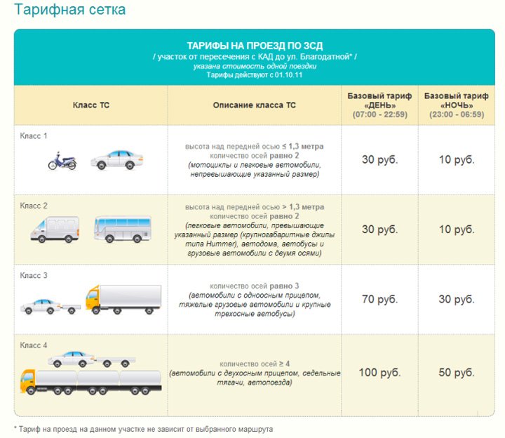 For large passenger cars such as Hummers, buses and trucks with 2 axles, the fare is identical to the price for cars of the previous category. But for vehicles with 3 axles (heavy trucks and large three-axle buses, and cars with single-axle trailers) the price will be 70 rubles during the day, and 30 rubles at night.
Truck tractors, road trains and cars with a 2-axle trailer pay a fare of 100 rubles during the day and 50 rubles at night. You can pay for travel either in cash or using a contactless smart card and transponder.
Along the newly opened central section of the Western High-Speed Diameter. To say that we were impressed is to say nothing at all. From the toll gate on Bogatyrsky Prospekt to the exit to Dekabristov Island - 4 (!!!) minutes, to Ekateringofka - about 12, and we didn’t even accelerate beyond a hundred. The delight after the trip was smeared with a greasy layer on my face, so after a couple of hours we went to look at all this beauty with aleksorama . At the same time, we made a short movie, otherwise we only took photos with Sergei. First a video, there is a nice music and x4 acceleration, then a photo post from Sergei.
P.S. The hellish hell with payment at conventions/arrivals at Bogatyrsky has almost resolved, Yandex.Traffic today has already begun to depict a more or less calm situation. We are waiting for payment to be introduced :)
Today the company launched the central section of the WHSD, which opened the day before yesterday.
We came from the north and drove to the exit at Ekateringofka. Of course, compared to what it was, it’s like teleportation: 7 minutes and you’re on Vasilyevsky. 12 - and you are on Gutuevsky Island, and there it’s not far from Obvodny. It still seems somewhat unrealistic out of habit. They don't charge me yet - it's a test month or two.
Here is a map of this “puncture” through the entire city. The newly discovered section is red, it is the most difficult in terms of labor intensity and cost. There is a mini-tunnel and several bridges, including a high-rise one over Kanonerka and the Sea Canal. Also, Vasilyevsky Island will no longer be isolated during the construction of bridges: it will be possible to arrive there at any time via the WHSD.
2. And we turned around and drove into the WHSD Center near the Ekateringofka embankment. As you can see, the payment collection post is still under construction.
4. To Bogatyrskoe - 13 km! Just about 10 minutes drive. Fantastic.
5. Yes, an interesting point, it caught my eye. For some reason, the coverage along the way “there” (from north to south) is better than in the upper tier (from south to north). Here it is not smooth and rough.
6. Above was the upper tier, and the lower one (when we were driving from Bogatyrskoye) looks like this. The road is very smooth.
7. Then the WHSD goes around Bely Island and crosses the Bolshaya Neva with a bridge. Vasilievsky Island and construction sites on the alluvial perimeter of the island are visible in the distance (on the left). Already clearly visible Gas scraper .
8. Another view of the bridge over the Bolshaya Neva.
9. On the left is the Markizova Puddle, the Gas Scraper is directly visible.
10. We drive onto the bridge in a bizarre bend.
11. We stopped for a short time with emergency lights.
12. View from the bridge. As you can see, not only the Sea Terminal is clearly visible, but also St. Isaac’s. There was a strong wind blowing, so I quickly took it off and ducked into the car.
13. We are moving towards Vaska.
14. Here the road goes into a depression below sea level.
15. The gas scraper is gradually becoming landmark No. 1.
16. Mini-tunnel under the Smolenka River canal (!).
17. We are right there.
18. Upstairs, new houses are being intensively built on the alluvial territory. It is curious that this is already the third layer on top of the Soviet sea facade: developers built and advertised houses with a “view of the Gulf of Finland”, then again and again. In general, we managed to fool customers with advertising twice and it’s not a fact that the trick won’t happen a third time :)
19. Now we cross the fairway of the Malaya Neva with a cable-stayed bridge - between Vasilyevsky and Krestovsky islands, while Petrovsky remains in the depths of the delta.
20. On the right is the long-suffering stadium. They didn’t stop here: it was dangerous, and the weather was very uncomfortable. The road is 4 lanes in one direction everywhere.
21. And this is what a transponder for traveling along the WHSD looks like. Now there are quite long queues behind him; yesterday I stood there for more than an hour.
22. And for dessert, I saw another beautiful and visual photo of the WHSD Center on FB.
The test mode of operation of the Central section of the Western High-Speed Diameter ends and a fee will be introduced on it from February 4, 2017. Moreover, at the same time, the payment collection scheme will be completely revised. The entire WHSD route is now divided into 5 tariff zones, each costing 60 rubles.
This is the base price when paying in cash or by credit card. Thus, the expected strong increase in the cost of travel along the WHSD has not happened since the new year and, contrary to expectations, travel along the entire route will cost 300 rubles (from the Scandinavia highway to the Ring Road in the south of the city). But for those who prefer to pay in cash or by card, the night rate is canceled. That is, the price of 60 rubles () per plot will be around the clock. Here is the official tariff zone diagram:
- Zone 1. Ring Road (South) - Blagodatnaya Street
- Zone 2. Blagodatnaya Street - Makarova Embankment (Vasilievsky Island)
- Zone 3. Makarova Embankment (Vasilievsky Island) - Future interchange with Shuvalovsky Prospekt
- Zone 4. Future interchange with Shuvalovsky Prospekt - Ring Road (North)
- Zone 5. Ring Road (North) – Highway E-18 “Scandinavia”
UPD: From May 15, 2017, to encourage drivers to use transponders, an increase to 100 rubles is introduced. fee when exiting Bogatyrsky Prospekt when paying in cash or by credit card.
UPD: From July 22, 2017 to 100 rubles. The cost of travel in any zone increases when paying in cash or by credit card. Traveling the entire WHSD route when paying in cash at each point will cost 500 rubles. The experiment at the exit to Bogatyrsky Prospekt was apparently considered successful; now the experience extends to the entire route and using cash has become as unprofitable as possible. The only surprising thing is why the developers of the tariff schedule go the other way - instead of increasing the discount on the transponder or making more flexible tariffs, they set protective tariffs when paying in cash.
When using a transponder, the savings will be 15% compared to paying in cash. In addition, thanks to the recently introduced Flow+ system, if the route is less than the tariff zone, the transponder owner will save not 15%, but even more, since the cost will be calculated based on the actual distance traveled. This is due to the fact that not all exits have toll booths, but all have devices for reading the transponder signal. This allows us to cut tariff zones even more finely for this category of highway users. Another significant advantage for transponder users is the preservation of the night tariff (50% discount applies from midnight to 6 am).
At the end of the review, a few photos of the WHSD and video:


We tested the central section of the WHSD, which opened the day before yesterday.
We came from the north and drove to the exit at Ekateringofka. Of course, compared to what it was, it’s like teleportation: 7 minutes and you’re on Vasilyevsky. 12 - and you are on Gutuevsky Island, and there it’s not far from Obvodny. It still seems somewhat unrealistic out of habit. They don't charge me yet - it's a test month or two.
Here is a map of this “puncture” through the entire city. The newly discovered section is red, it is the most difficult in terms of labor intensity and cost. There is a mini-tunnel and several bridges, including a high-rise one over Kanonerka and the Sea Canal. Also, Vasilyevsky Island will no longer be isolated during the construction of bridges: it will be possible to arrive there at any time via the WHSD.
2. And we turned around and drove into the WHSD Center near the Ekateringofka embankment. As you can see, the payment collection post is still under construction.
4. To Bogatyrskoe - 13 km! Just about 10 minutes drive. Fantastic.
5. Yes, an interesting point, it caught my eye. For some reason, the coverage along the way “there” (from north to south) is better than in the upper tier (from south to north). Here it is not smooth and rough.
6. Above was the upper tier, and the lower one (when we were driving from Bogatyrskoye) looks like this. The road is very smooth.
7. Then the WHSD goes around Bely Island and crosses the Bolshaya Neva with a bridge. Vasilievsky Island and construction sites on the alluvial perimeter of the island are visible in the distance (on the left). Already clearly visible.
8. Another view of the bridge over the Bolshaya Neva.
9. On the left is the Markizova Puddle, the Gas Scraper is directly visible.
10. We drive onto the bridge in a bizarre bend.
11. We stopped for a short time with emergency lights.
12. View from the bridge. As you can see, not only the Sea Terminal is clearly visible, but also St. Isaac’s. There was a strong wind blowing, so I quickly took it off and ducked into the car.
13. We are moving towards Vaska.
14. Here the road goes into a depression below sea level.
15. The gas scraper is gradually becoming landmark No. 1.
16. Mini-tunnel under the Smolenka River canal (!).
17. We are right there.
18. Upstairs, new houses are being intensively built on the alluvial territory. It is curious that this is already the third layer on top of the Soviet sea facade: developers built and advertised houses with a “view of the Gulf of Finland”, then again and again. In general, we managed to fool customers with advertising twice and it’s not a fact that the trick won’t happen a third time :)
19. Now we cross the fairway of the Malaya Neva with a cable-stayed bridge - between Vasilyevsky and Krestovsky islands, while Petrovsky remains in the depths of the delta.
20. On the right is the long-suffering stadium. They didn’t stop here: it was dangerous, and the weather was very uncomfortable. The road is 4 lanes in one direction everywhere.
21. And this is what a transponder for traveling along the WHSD looks like. Now there are quite long queues behind him; yesterday I stood there for more than an hour.
22. And for dessert, I saw another beautiful and visual photo of the WHSD Center on FB.
I will make a video in better weather times, for now only photos.
Objective of the project: Creation of a toll expressway to ensure road transport of passengers and goods in the directions of their greatest concentration and to connect the transport hub of St. Petersburg, including the Big Port, to the country’s highway network
Project description: The total length of the route is 46.6 km; it will include sections designed for 4, 6 and 8 lanes. Overpass sections will make up 55% of the length of the highway, sections on the roadbed - 45%. The WHSD provides for the construction of 14 transport interchanges at different levels and unique bridge structures with under-bridge dimensions above the ship fairway of 55 m and 35 m, the construction of which will be carried out for the first time in Russia.
The design speed on the highway is 120 km/h.
Project location: Southern section – 11.50 km. From the transport interchange with the Ring Road to the border of the Big Sea Port of St. Petersburg.
The central section is 8.95 km. From the Great Sea Port of St. Petersburg along the western tip of Vasilievsky Island, to the North Primorsky part of the city.
Northern section – 26.15. It goes beyond the urban development in the North Primorsky part of the city, crosses the Ring Road and is the new entrance to the city of the E-18 Scandinavia highway.
Project status: In 2000, the Route Selection Act was approved. The design of the highway has been underway since 2004; the design will be fully completed by the end of 2006. In the fall of 2005, work began on the construction of the first stage of the southern section. A competition for the right to conclude a Concession Agreement on the design, construction, financing and operation of the WHSD highway in St. Petersburg will be announced in November 2006.
Project budget: 83,644 million rubles (including 13,798 million rubles from the city budget, 28,001 million rubles from the Investment Fund of the Russian Federation)
Project implementation form: Public private partnership. According to information from the Official Portal of the Administration of St. Petersburg (dated October 25, 2006)
Construction queues
1st stage | Southern section (from the transport interchange with the Ring Road to the transport interchange with the Ekateringofka River embankment) |
| 2nd stage |
|
| 3rd stage | Northern section (from the transport interchange with Bogatyrsky Ave. to the E-18 Scandinavia highway) |
4th stage | Southern section (from the transport interchange from the embankment of the Ekateringofka River to Kanonersky Island) |
Central section (from Kanonersky Island to the transport interchange with Shkipersky Channel) |
|
5th stage | Central section (from the transport interchange with Shkipersky Protok to Primorsky Ave.) |
Northern section (from Primorsky Ave. to the transport interchange with Bogatyrsky Ave.) |